
 Cleveland 19 News
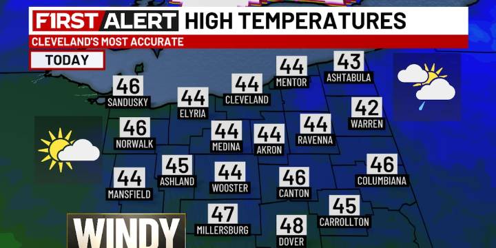
CLEVELAND, Ohio (WOIO) - Much cooler temperatures are expected throughout the day behind a cold front that moved through Saturday evening.
In fact, temperatures will be fairly steady in the low to mid 40s all day long.
This is accompanied by a blustery wind out of the northwest between 15 and 25 mph.
Gusts may occasionally reach 40 mph.
A mix of clouds and sun this morning turns more mostly cloudy this afternoon.
There is also the opportunity for lake-effect showers east of Cleveland, focused mainly in the primary snowbelt.
Some snow or graupel may mix in with the rain, but no accumulation is expected. Download the 19 First Alert Weather App
For tonight, lake-effect showers continue east while the rest of the region begins to see breaks in the clouds.
The wind remains elevated as

 AlterNet
 Fortune
 People Top Story
 Glam
Glam Truthout
 Raw Story
 Billboard
 Bozeman Daily Chronicle Sports
 Bored Panda