
 WIS News 10
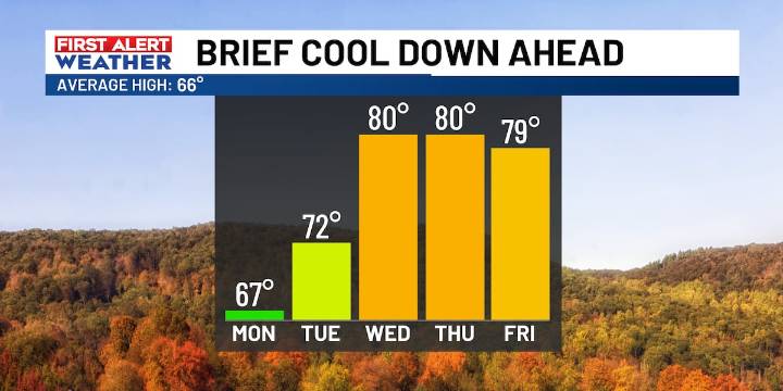
COLUMBIA, S.C. (WIS) - Today’s cold front will briefly drop temperatures back to the 60s Monday to kick off the new work.
First Alert Headlines
Cool, dry air funnels in tonight in the wake of a cold front.
Highs close to normal Monday in the 60s.
Another quick warm-up on tap by the middle of the week.
First Alert Summary
Winds will become lighter through this evening now that the cold front is tracking farther south of the area. Cooler air will result in overnight temperatures falling to the upper 30s to lower 40s by early Monday morning. Have a jacket ready to go!
Monday’s forecast will feature plenty of sunshine and near normal temperatures to start the new work week! Highs are expected to peak in the middle to upper 60s in the afternoon, which is a lot closer to average for mid-N

 CNN Politics
 The Texas Tribune Crime
 The Babylon Bee
 Orlando Sentinel Sports
 Raw Story
 People Top Story
 Essentiallysports Football
 The List
 Mediaite
 Tom's Guide