
 KFVS12
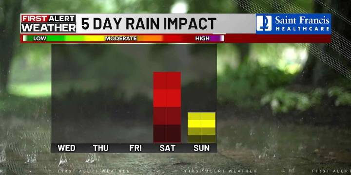
(KFVS) - Today will be much cooler with highs in the mid to upper 40s and breezy.
First Alert Meteorologist Cassie Campbell says we can expect wind gusts out of the northwest around 30 mph.
Thanksgiving is looking cool and sunny.
Highs tomorrow are forecasted in the low to mid-40s. Overnight Thursday into Friday, temperatures will quickly drop below freezing.
If you are headed out early Friday morning, make sure to bundle up. Expect another sunny and chilly day on Friday.
Currently, precipitation could start arriving overnight Friday into Saturday.
Early Saturday morning, some precipitation could fall as snow showers or a wintry mix, but it will quickly turn to rain as temperatures increase.
No impacts to travel are expected, but roadways will be wet, so still be cautious.
Get upda

 WMTV NBC15
 WOWT
WOWT JACOBIN
 Joplin Globe Sports
 New York Post
 Raw Story
 The Daily Beast