
 USA TODAY National
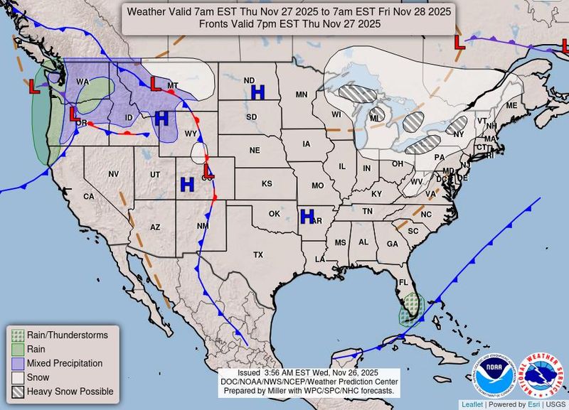
Thanksgiving Day is here at last, and for tens of millions of folks in the eastern half of the country, brisk, cold winds will be the main weather story.
In fact, the coldest air of the season so far will be surging across the central and eastern U.S., with many areas of the Plains, Midwest, and the East seeing temperatures dropping well below normal as a strong cold front gradually exits off the East Coast, the National Weather Service said.
With the exception of the lake-effect snow concerns around the Great Lakes, much of the eastern half of the country should be dry on Thanksgiving Day, but much of the Northeast will see strong, gusty winds.
Thus, many areas will see very blustery conditions for any outdoor Thanksgiving festivities, including the Macy's Thanksgiving Day Parade in New York City, the weather service said.
Lake-effect snow near the Great Lakes
Heavy lake-effect snowfall should spread downwind of all of the Great Lakes by later Thanksgiving Day and into Friday, Nov. 28. As much as 1 to 2 feet of new snowfall is expected to fall downwind of all of the Great Lakes going through the end of the holiday week.
"Whiteout conditions are expected and will make travel treacherous and potentially life-threatening," the weather service said. "Visibility and road conditions may change rapidly over short distances in lake-effect snow."
Don't forget about the West!
The western U.S. will remain milder than normal through the Thanksgiving holiday, the weather service predicts.
The Pacific Northwest will be unsettled as a storm system just offshore drives locally heavy rains for the coastal ranges of western Washington and Oregon. This will translate into heavy snowfall for the high terrain of the Washington Cascades, and this moisture and a threat of heavy snow will spread east into the northern Rockies and portions of the northern High Plains by Friday, Nov. 28.
Snow possible over weekend for Northern Rockies and midwest
The weather service is increasingly confident that threat of heavy snow will turn into a winter storm for the Northern and Central Rockies that could stretch from the central plains to the Midwest early in the weekend, potentially interfering with post-Thanksgiving travel.
There is an 80% chance of more than 6 inches of snow stretching from Sioux Falls, Iowa to Buffalo, New York before Sunday, Nov. 30. That range dips as far south as Peoria, Illinois.
This article originally appeared on USA TODAY: Here's your Thanksgiving Day weather forecast
Reporting by Doyle Rice and Sarah D. Wire, USA TODAY / USA TODAY
USA TODAY Network via Reuters Connect

 KETK
KETK The Newport Daily News
 KTSM 9 News
 America News
 Cover Media
 ABC11 WTVD
 Daily Voice
 Associated Press US and World News Video
 Raw Story