
 Cover Media
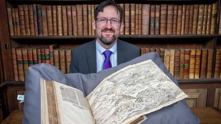
Researchers say that a 500-year-old map depicting the Holy Land was printed the wrong way round - yet it has continued to influence people's ideas of its geography to this day.
The first Bible to include a map showing where events took place was published in 1525.
Although the engraving showed the Mediterranean to the east rather than the west, its inclusion set a precedent that scholars from Cambridge University say continues to influence modern ideas of borders in the region.
"This is simultaneously one of publishing's greatest failures and triumphs," says Nathan MacDonald, Professor of the Interpretation of the Old Testament at the University of Cambridge.
"They printed the map backwards so the Mediterranean appears to the east of Palestine. People in Europe knew so little about this part of the world that no one in the workshop seems to have realised. But this map transformed the Bible forever and today most Bibles contain maps."
In research published in The Journal of Theological Studies, Professor MacDonald argues that the map, created by Lucas Cranach the Elder and printed in Zürich, not only helped turn the Bible into a Renaissance book but shaped emerging ideas of territorial division.
"It has been wrongly assumed that biblical maps followed an early modern instinct to create maps with clearly marked territorial divisions," MacDonald says. "Actually, it was these maps of the Holy Land that led the revolution.
"As more and more people gained access to Bibles from the 17th century, these maps spread a sense of how the world ought to be organised and what their place within it was. This continues to be extremely influential."
Ideas of borders in the Holy Land have been a long-term source of conflict in the region, with the Israeli-Palestinian conflict centred on Ancient and modern claims to land.
Only a handful of copies of Christopher Froschauer's 1525 Old Testament survive. Trinity College Cambridge's Wren Library holds one of the rare examples.
The map shows the stations of the Israelites' wilderness journey and the division of the Promised Land into twelve tribal territories. These delineations reflected a specifically Christian view of inheriting the holy sites of scripture. The design drew on medieval traditions that divided biblical Israel into simple horizontal strips, heavily influenced by the ancient historian Josephus, who sought to resolve conflicting biblical accounts.
According to MacDonald, "Joshua 13-19 doesn't offer an entirely coherent, consistent picture of what land and cities were occupied by the different tribes. There are several discrepancies. The map helped readers to make sense of things even if it wasn't geographically accurate."

 The Atlantic
 The Conversation
 Crooks and Liars
 The Travel
 AlterNet
 ABC News