
 WAFB
WAFB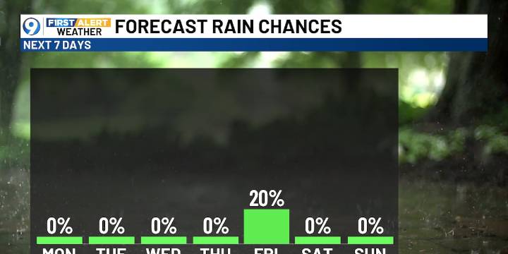
BATON ROUGE, La. (WAFB) - After a stretch of gloomy days, sunshine and drier weather return following last night’s cold front. The cooler air sticks around briefly before temperatures gradually warm again by mid to late week.
TODAY’S FORECAST
Clouds linger to start the day with a cool north breeze filtering in behind the passed cold front.
Temperatures may briefly fall through late morning before recovering into the mid-50s this afternoon as skies begin to clear. Expect temperatures to fall quickly after sunset under mostly clear skies.
TUESDAY MORNING CHILL
With clearer skies and a continued northerly breeze, temperatures drop into the low to mid-30s overnight, making for a chilly start Tuesday morning.
MORE SUNSHINE, LESS RAIN
Rain chances remain minimal this week as dry air holds

 WWL-TV
 WBRZ News
 WTHR
WTHR WDSU New Orleans
 Nola Crime
 The Monroe News
 The Conversation
 @MSNBC Video