
 KCCI 8
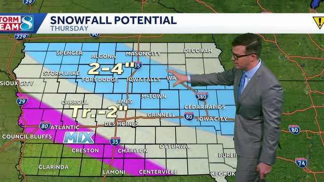
DES MOINES, Iowa —
Snow will be increasing through the morning with more snow and wintry mix for the afternoon.
Closings | Interactive Radar | Weather Alerts | Skycams
Our temperatures will be below freezing for the entire day which will lead to the ice chance, but the highest threat for ice will be around and after sunset when we lose the radiational heating of the sun. The northeastern half of the state will have the more impactful snow and ice threat which is where we find the winter weather advisory going into effect from noon today to midnight. Expect slick travel in these areas through the day with the worst of it after 3 p.m. The metro will have a band of snow push over with a lighter and lower precipitation chance during rush hour.
The snow chances will come to an end ove

 The Oregonian Public Safety
 AccuWeather Severe Weather
 Syrancuse.com
 KKTV 11 News
 WIS News 10
 ABC 6 WPVI-TV
 KOIN News
 KOMO News
 KETV NewsWatch 7
 Charleston Gazette
 AlterNet