
 USA TODAY National
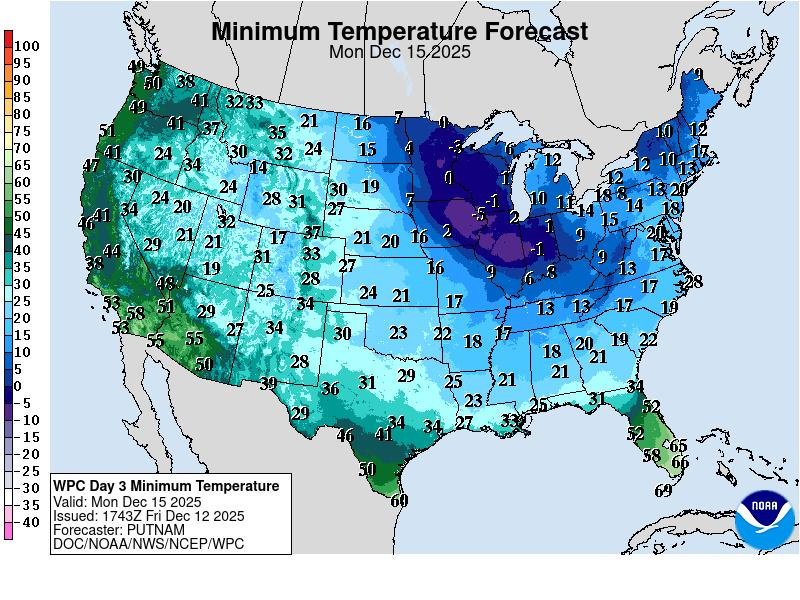
Forecasters say the first snow storm of the season to take aim at major Northeast cities will dump several inches of snow over the weekend, followed by a bitter Arctic blast courtesy of the polar vortex.
The cold won't last, as forecasters expect winter reprieve in the form of a coast-to-coast mild spell, which could doom dreams of a White Christmas for millions.
But first, the weekend storm will spread light to moderate amounts of snow across the central and northeastern U.S.
Calling it a 'baby Nor'easter," Weather Trader meteorologist Ryan Maue said in an email to USA TODAY that a huge population will see at least 3 inches of snowfall from the storm.
On Sunday Dec. 14, "Snowfall could be heavy in a burst of 3-6 hours and add up 3 inches to 6 inches – maybe more," he said.
By the time the storm is over later Sunday Dec. 14, 1 to 6 inches of snow will have fallen along a 1,500-mile swath from the northern Plains to the shores of southern New England, according to an online forecast from AccuWeather. The storm will focus along much of Interstate 70 in the Ohio Valley region and then along the heavily populated I-95 corridor from Maryland to Massachusetts.
'Mother lode of cold air' headed for US
The long-awaited blast of bitterly cold Arctic air will spread across the north-central U.S. Saturday Dec. 13. And it's headed toward the East and South.
"There is a massive area of air in northwestern Canada where temperatures are 20 to 30 degrees below zero Fahrenheit, and it is on its way southeastward into the U.S.," AccuWeather chief on-air meteorologist Bernie Rayno said in an online forecast. "This is the mother lode of cold air and is a term I don't use lightly."
"Cold high pressure will spread much below normal temperatures across the Midwest, Ohio and Tennessee Valleys, and all the way to the Gulf Coast early Monday Dec. 15, with temperatures 15 to 30 degrees below normal, the National Weather Service said.
A few record lows are possible, and wind chills may dip as low as the teens as far south as the southeastern Atlantic and Gulf Coasts Sunday night/Monday morning, the weather service said.
The weather service in Columbia, South Carolina, issued an "extreme cold watch" for the region, warning that "an extended period of freezing temperatures could cause ruptured water pipes. Be sure to protect outdoor faucets and drip water to help prevent ruptured pipes."
Snow storm forecast: How much will it snow?
Wondering how much snow is in the forecast? USA TODAY's detailed winter weather forecast map below lets you explore where snow is expected over the next few hours and days.
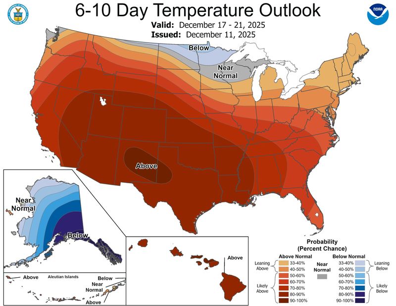
Forecast predicts December thaw
However, the weather service said that a weather system over the Western U.S. will allow temperatures to reach 15 degrees to 25 degrees above seasonal averages, spreading east across much of the lower 48 for midweek and beyond, "creating a December thaw."
“While it may feel like Christmastime already with the cold and snow, the bitterly cold pattern is not expected to last through the holidays," said AccuWeather meteorologist Paul Pastelok.
The vast snow cover still being added to by the storm pattern through this weekend is likely to be eroded by higher temperatures before Christmas, AccuWeather said. This could wreak havoc with dreams of a white Christmas for millions.
"Don't assume because it is cold and snowy now that it will be so on Christmas Day," Pastelok said in an online forecast. “Skiers and snowboarders should take advantage of the cold air and fresh powder at the slopes that are open in the Appalachians. Ski and boarding conditions could deteriorate over Christmas week at some resorts as warmer air moves in.”
In the meantime, those wanting warmth or at least warm thoughts through this weekend can look to the Florida Peninsula and most areas west of the Rockies, except for foggy areas in California's Central Valley or flooded zones in the Pacific Northwest, AccuWeather said.
But could the polar vortex rear its ugly head yet again?
Maue said the ridge of high pressure will build across the Lower 48 from coast-to-coast into by Dec. 22, "but questions remain if Christmas is a 'blow torch' or the polar vortex can battle back and drop a few [very cold] troughs/lobes into the Great Lakes and Northeast," he said in an e-mail.
Maue said that eventually the warm pattern MUST break down, and the Canadian cold pool will find its way back into Lower 48. "However, no clear signals about when/how that will happen (yet)."
This article originally appeared on USA TODAY: First big snow storm to hit US as polar vortex sends coldest air yet
Reporting by Doyle Rice, USA TODAY / USA TODAY
USA TODAY Network via Reuters Connect

 NECN Providence
 Cowboy State Daily
 ABC6 Rhode Island
 Eyewitness News 3
 WAND TV
 NBC Connecticut
 Siskiyou Daily News
 Atlanta Black Star Entertainment