
 WESH 2 News
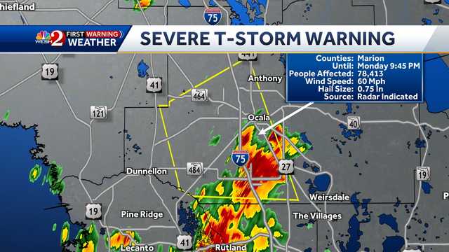
The National Weather Service has issued a severe thunderstorm warning for parts of Marion County until 9:45 p.m. Monday.
The warning was issued at 9:01 after a severe thunderstorm was located near Santos, around 7 miles south of Ocala and moving northwest at 25 mph. Hazards may include 60 mph winds and penny-size hail according to the NWS.
Locations impacted by the storm include Ocala, the Ocala airport Santos, Belleview, Summerfield and Lowell. This content is imported from Twitter. You may be able to find the same content in another format, or you may be able to find more information, at their web site. This content is imported from Twitter. You may be able to find the same content in another format, or you may be able to find more information, at their web site.

 America News
 Yahoo Canada
 WRAL News
 Ocala Star-Banner
 KLFY News 10
 Associated Press US and World News Video
 The Weather Channel
 NBC Chicago
 FOX News Videos