
 USA TODAY National
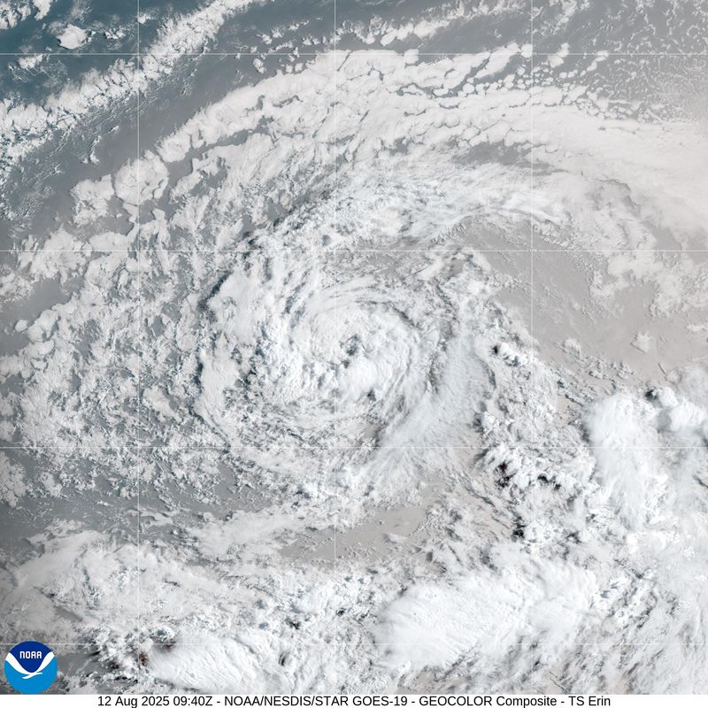
Editor's Note: Tropical Storm Erin is expected to strengthen into a hurricane. See the latest update on Wednesday, Aug. 13.
Tropical Storm Erin was moving quickly across the Atlantic Ocean, where it's expected to encounter warm waters and strengthen into a major hurricane, the latest advisory from the National Hurricane Center said.
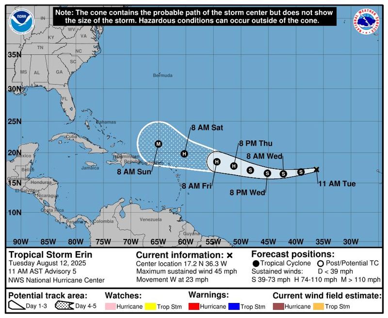
Erin was about 820 miles west of the Cabo Verde Islands with maximum sustained winds near 45 mph, according to an 11 a.m. ET bulletin published Tuesday, Aug. 12. The Miami-based hurricane center said Erin was moving west at 23 mph.
The center's windspeed forecast says Erin could become a hurricane on Thursday, Aug. 14, and reach major hurricane status by early Sunday, Aug. 17. A major hurricane is a term used for cyclones rated a Category 3 or higher with sustained wind speeds over 110 mph.
Though the hurricane center noted uncertainty in the long-range forecast, the most recent advisory showed Erin moving closer to the northern Caribbean islands over the weekend. AccuWeather senior meteorologist Alex DaSilva said the Erin could bring flooding rain and damaging winds to Puerto Rico and the U.S. Virgin Islands.
"People and businesses in the northeast Caribbean should be on high alert," DaSilva said in an online forecast.
It's too early to know what impact, if any, Erin will have on the Greater Antilles, the Bahamas, Bermuda and the east coast of the United States next week, the hurricane center said.
Meanwhile, a surface trough in the north-central Gulf is associated with a broad area of disorganized showers and thunderstorms. The system is not expected to develop before it moves inland, although locally heavy rainfall could produce flash flooding across portions of the Florida Panhandle, southern Alabama, southern Mississippi and southeastern Louisiana over the next day or so, according to the hurricane center.
Lastly, the hurricane center said it was keeping an eye on a nontropical area of low pressure a few hundred miles southeast of Nova Scotia, Canada.
"Some limited tropical or subtropical development is possible over the next day or so as the low meanders near the relatively warm waters of the Gulf Stream," the hurricane center said. But the system is forecast to move northward over cooler waters, which would lower its chances of further tropical development.
Tropical Storm Erin path tracker
Illustrations include an array of forecast tools and models, and not all are created equal. The hurricane center uses only the top four or five highest performing models to help make its forecasts.
Tropical Storm Erin spaghetti models
Illustrations include an array of forecast tools and models, and not all are created equal. The hurricane center uses only the top four or five highest performing models to help make its forecasts.
Forecasters also watching Hurricane Henriette in Pacific
Meanwhile, in the Pacific, the hurricane center said it is keeping tabs on Hurricane Henriette.
In an 11 p.m. Hawaiian Standard Time advisory on Monday, Aug. 11, forecasters said Henriette was about 730 miles north of Honolulu, with maximum sustained winds near 75 mph and higher gusts.
The hurricane center said further weakening is forecast for the next few days, and Henriette is expected to become a post-tropical cyclone by early Thursday, Aug. 14. There are no threats to land.
How do hurricanes form?
Hurricanes are born in the tropics, above warm water. Clusters of thunderstorms can develop over the ocean when water temperatures exceed 80 degrees. If conditions are right, the clusters swirl into a storm known as a tropical wave or tropical depression.
A tropical depression becomes a named tropical storm once its sustained wind speeds reach 39 mph. When its winds reach 74 mph, the storm officially becomes a hurricane.
Prepare now for hurricanes
Delaying potentially lifesaving preparations could mean waiting until it’s too late. "Get your disaster supplies while the shelves are still stocked, and get that insurance checkup early, as flood insurance requires a 30-day waiting period," the National Oceanic and Atmospheric Administration recommends.
- Develop an evacuation plan. If you are at risk from hurricanes, you need an evacuation plan. Now is the time to begin planning where you would go and how you would get there.
- Assemble disaster supplies. Whether you’re evacuating or sheltering in place, you’re going to need supplies not just to get through the storm but for a possibly lengthy aftermath, NOAA said.
- Get an insurance checkup and document your possessions. Contact your insurance company or agent now and ask for an insurance checkup to make sure you have enough insurance to repair or even replace your home and belongings. Remember, home and renters insurance doesn’t cover flooding, so you’ll need a separate policy for it. Flood insurance is available through your company, agent or the National Flood Insurance Program. Act now, because flood insurance requires a 30-day waiting period.
- Create a family communication plan. NOAA says you should take the time now to write down a hurricane plan and share it with your family. Determine family meeting places and make sure to include an out-of-town location in case of evacuation.
- Strengthen your home. Now is the time to improve your home’s ability to withstand hurricanes. Trim trees; install storm shutters, accordion shutters, and impact glass; seal outside wall openings.
Gabe Hauari is a national trending news reporter at USA TODAY. You can follow him on X @GabeHauari or email him at Gdhauari@gannett.com.
This article originally appeared on USA TODAY: Tropical Storm Erin expected to strengthen into major hurricane: See tracker
Reporting by Gabe Hauari and Christopher Cann, USA TODAY / USA TODAY
USA TODAY Network via Reuters Connect

 WESH 2 News
 10 Tampa Bay
 CBS4 Miami
 America News
 WVLT
WVLT CBS News
 The radio station 99.5 The Apple
 Rolling Stone
 Raw Story
 The Babylon Bee
 The US Sun Sports
 Oh No They Didn't