
 WESH 2 News
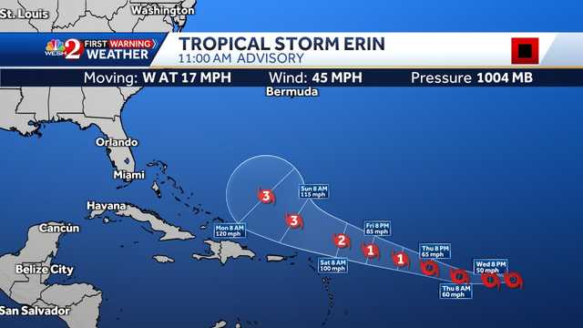
Tropical Storm Erin is expected to strengthen into a hurricane in a couple of days, according to the National Hurricane Center.
As of the 11 a.m. advisory, Erin was located about 1,305 miles east of the Northern Leeward Islands and had maximum sustained winds of 45 mph with a minimum central pressure of 1,004 mb.
Gradual strengthening is expected to begin on Wednesday. Erin could become a hurricane by late Thursday into Friday morning. A west-northwestward motion beginning Thursday night will continue into the weekend. On the forecast track, the center of Erin is likely to move near or just north of the northern Leeward Islands over the weekend.
By the weekend, Erin could become the first major hurricane of the 2025 Atlantic season.
Erin is moving west at 27 mph, according to the NHC.

 10 Tampa Bay
 CBS4 Miami
 America News
 Columbia Daily Tribune
 KTOO
KTOO Press-Enterprise
 CBS News
 The Denver Post
 Florida Today
 FOX Weather
 The Post and Courier
 The Cut