
 USA TODAY National
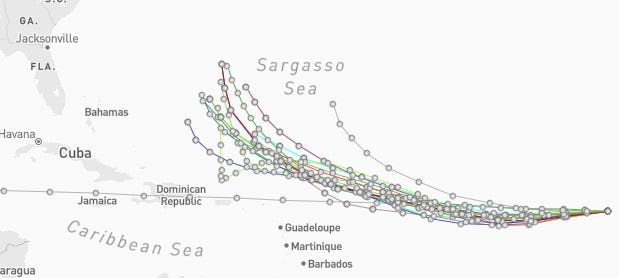
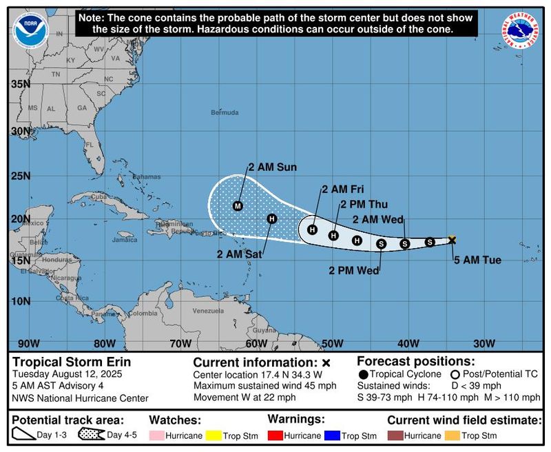
Tropical Storm Erin, which is still thousands of miles from the U.S. East Coast in the central Atlantic Ocean, is traveling west and forecast to strengthen into the season's first hurricane by Aug. 14, the National Hurricane Center said.
But will it hit the United States?
Most reliable computer models that meteorologists use to forecast storms show Erin curving away from the United States, spinning off the East Coast in mid-August.
"It is too soon to discount – or pinpoint – USA landfall impacts from Erin but based upon current model guidance – the chance RIGHT NOW is low, at less than 10%," said Weather Trader meteorologist Ryan Maue in an email to USA TODAY Aug. 11.
WPLG-TV hurricane specialist Michael Lowry added a note of caution, telling USA TODAY that "it’s worth reiterating that forecasts 5 to 10 days out are subject to large errors, so we’ll need to hang tight before confidently giving the U.S. the all-clear."
Maue predicted that "as the Lower 48 comes into view of Erin in the next few days, our models will become more confident/certain on the eventual outcome — so we should know on Thursday (Aug. 14) what will happen."
However, even if Erin does avoid landfall on the United States, "there will be a significant increase in seas, surf and rip currents along the East Coast beaches next weekend into the following week," AccuWeather senior meteorologist Chad Merrill said.
What forces are guiding Erin?
As is often the case with Atlantic hurricanes, Erin's path will be primarily determined by the strength of the Bermuda High, a semi-permanent ridge of high pressure that sits over the western Atlantic Ocean in the summer.
The stronger the Bermuda High, the more of a threat Erin is to the United States. A weaker Bermuda High is better news.
"Erin will be guided along by the northeast trade winds initially and then the clockwise circulation around the massive Bermuda High over the central Atlantic," AccuWeather lead hurricane expert Alex DaSilva said.
As of the morning of Aug. 12, the hurricane center reported that Erin should head west and slow down as the Bermuda High weakens slightly. Later in the forecast period, the high is expected to weaken a little more, and a more west-northwestward track is likely.
Houston-based meteorologist Matt Lanza said the track forecast is in decent model agreement, "showing a good, tight track consensus through Sunday or Monday, bringing the storm north of the Caribbean islands."
Warm waters could fuel major hurricane
All signs point to Erin reaching major hurricane status, the hurricane center said. This means the storm will reach Category 3 status, with sustained wind speeds of at least 111 mph.
The forecast is due to warm waters where the storm is expected to track, providing fuel for the storm, the hurricane center said.
Low wind sheer could also help Erin strengthen
There will also be a lack of wind shear that acts to tear developing hurricanes apart.
"Low wind shear (a lack of disruptive winds) north of the Caribbean and much warmer water could really allow Erin to strengthen rapidly late this week and this weekend," AccuWeather meteorologist Bernie Rayno said in an online report.
What parts of the US coast are most at risk?
AccuWeather said that a major hurricane passing 100 miles east of the United States or west of Bermuda could still bring tropical storm conditions in terms of wind, heavy seas and perhaps heavy rain.
"Land that extends farther to the east might be the most prone in this case, such as coastal areas of North Carolina, Long Island, New York, and Cape Cod, Nantucket and Martha's Vineyard in New England," said AccuWeather meteorologists Alex Sosnowski and Elizabeth Danco in an online report.
In Canada, Nova Scotia and Newfoundland could be facing more significant impacts from Erin.
How worried should people be?
The hurricane center, as always, stressed caution: It is still too early to determine what impacts, if any, Erin may bring to the east coast of the United States, the hurricane center said Aug. 12.
However, the hurricane center said "As we approach the climatological peak of the hurricane season, this is an opportune time to ensure your preparedness plans are in place."
Lanza said the odds favor a miss: "History favors an out to sea track, though not at 100 percent. Of the 56 known named storms track within 120 nautical miles of Erin's forecast position in 24 hours, 51 of them have gone out to sea, a U.S. hit rate of about 9 percent."
This article originally appeared on USA TODAY: Will Tropical Storm Erin hit the US or turn? Here's what early forecasts say.
Reporting by Doyle Rice, USA TODAY / USA TODAY
USA TODAY Network via Reuters Connect

 Democrat and Chronicle
 SIAdvance
 WFMY News 2
 America News
 KTOO
KTOO Press-Enterprise
 Columbia Daily Tribune
 FOX Weather
 Florida Today
 The Daily Sentinel
 New York Post
 The Daily Beast