
 21Alive News
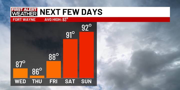
FORT WAYNE, Ind. (WPTA) - Temperatures back off into the mid to upper 80s for the end of the workweek, but we’ll heat up into the 90s by this weekend!
Skies start out cloudy for the beginning of Wednesday, but later in the day we’ll see sunshine. Some stray showers are possible at times, but this doesn’t look to be long-lasting. Humidity trends shift down ever so slightly for today and tomorrow, dropping us out of the ‘tropical’ category into the ‘muggy’ category. The tropical humidity range will return by the weekend.
Your Next First Alert: Beyond the hot weekend, I am keeping an eye out for a bit of relief at the end of next week. A cold front looks to push in for the end of next workweek, trending temperatures into the Midwest back in the 70s and 80s for a period of time.
Today : AM

 MyNorthwest
 KONP
KONP Fox 11 Los Angeles Sports
 FOX 32 Chicago
 AccuWeather Severe Weather
 NBC News
 Nicki Swift
 Raw Story