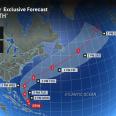
Hurricane Erin is forecast to take a curved path between the United States and Bermuda this week and remain a major storm with a far-reaching influence. Although the eye of the hurricane will remain over the ocean, AccuWeather meteorologists warn it could still have damaging impacts to coastlines along the eastern US.
As of 11pm Sunday, Erin's maximum sustained winds increased to 130 mph, making it a major Category 4 hurricane once again with the eye about 130 miles to the east-northeast of Grand Turk Island. Erin was moving northwest at 12 mph. On Saturday, it reached Category 5 status with 160-mph winds.
As of Sunday night, tropical storm warnings were in effect for the Turks and Caicos and the southeastern Bahamas.
Erin has experienced a common hurricane phenomenon called an eyewall

 AccuWeather Severe Weather

 Local News in South Carolina
 America News
 WISC-TV Channel 3000
 CNN
CNN Democrat and Chronicle
 FOX 13 Tampa Bay Crime
 New York Post
 Denver7 News
 Raw Story
 ABC 7 Chicago Entertainment