
 WESH 2 News
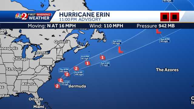
The outer bands of Hurricane Erin are approaching the North Carolina Outer Banks on Wednesday evening.
Erin is a Category 2 storm with maximum sustained winds of 110 mph. Latest Forecast
° F FEELS LIKE
HOURLY
DAILY RADAR TRAFFIC
As of 11 p.m., Erin was located about 485 miles west of Bermuda and had a minimum central pressure of 942 mb. The hurricane is moving north-northwest at about 14 mph.
A turn toward the north-northeast is expected later Wednesday and Thursday, followed by a faster motion toward the northeast and east-northeast by Thursday and Friday. This content is imported from Twitter. You may be able to find the same content in another format, or you may be able to find more information, at their web site.
On the forecast track, the center of Erin will move over

 News Center MAINE
 FOX 51 Gainesville Crime
 CBS4 Miami
 America News
 CBS News Video
 WCNC Charlotte Weather
 The Atlanta Journal-Constitution Crime
 CBS News
 The List