
 WWSB
WWSB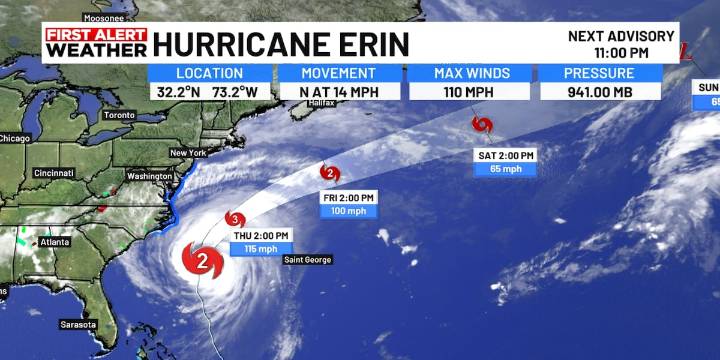
SARASOTA, Fla. (WWSB) - Hurricane Erin is getting better organized once again as it moves over the Gulf stream in the Atlantic. It has now made that northerly turn and is expected to continue in that direction tonight turning to the NE on Thursday.
Winds are now at 110 mph making it a category 2 hurricane but is likely to become a major cat. 3 hurricane once again late Wednesday night or early Thursday morning as the pressure continues to fall.
The storms projected path is over some very warm water over the next 24 hours. This will likely bring the winds up to 115-120 mph. Anything above 110 mph makes it a major hurricane. Thankfully the core of the hurricane winds will stay offshore and not reach the U.S. coast.
It will begin to be picked up by a trough of low pressure and cold front m

 Orlando Sentinel
 ClickOrlando
 WESH 2 News
 FOX 13 Tampa Bay Crime
 Political Wire
 The List
 The Daily Beast
 Raw Story