
 WYFF Greenvile
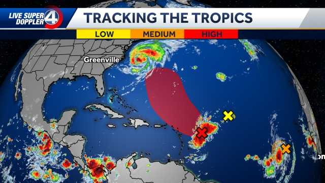
We are watching two areas of interest in the tropics following Hurricane Erin. Latest Forecast
° F FEELS LIKE
HOURLY
DAILY RADAR TRAFFIC
One system, which is currently located near the Leeward Islands, could form into a tropical depression toward the end of this week or this weekend. If this system were to form, it would likely be named Fernand.
WYFF 4
The EURO model keeps it weak and curves it out to sea like Erin. The GFS model originally showed it becoming a risk for the U.S. before Labor Day, but it is now similar to the EURO model.
Spaghetti Models
The bottom line is there is confidence that a system will form, but its exact track will not be clear until Erin exits the region.
Another tropical wave a couple of hundred miles southwest of the Cabo Verde Islands has a

 NBC News
 KPTV Fox 12 Oregon
 Associated Press US and World News Video
 Fox 11 Los Angeles Sports
 WTOC 11
 New York Post
 FOX 10 Phoenix Latest
 KTVU San Francisco
 WAFB
WAFB TownTimes news.com
 The Fayetteville Observer Sports