
 Northern News Now
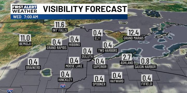
TUESDAY EVENING: A few scattered showers remain, mainly over NW WI and Pine, Aitkin, and Carlton Counties. Otherwise, we’ll see some widespread fog develop overnight with winds coming off of Lake Superior. Lows will be in the 50s.
WEDNESDAY: Persistent east winds move into the region keeping temperatures cooler near Lake Superior through Saturday. Highs reach the 70s inland with 60s near the lake with partly to mostly cloudy skies.. Patchy dense fog redevelops overnight with lows in the 50s.
THURSDAY: Highs remain in the 70s inland with 60s near the lake. Skies will be partly to mostly cloudy skies. Some patchy fog may redevelop overnight with lows in the 50s.
FRIDAY: A slight chance for rain returns Friday with highs in the 60s near the lake and 70s inland. Skies will be mostly clo

 KSL Utah
 KPTV Fox 12 Oregon
 AccuWeather Severe Weather
 KXLH
KXLH Raw Story
 YourTango Horoscope