
 KKTV 11 News
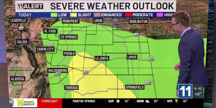
Strong to severe storms with hail, wind and a tornado possible.
Cool today and Thursday.
Warmer and drier Friday and this weekend.
WEDNESDAY: Storms redevelop this afternoon. Some could be strong to severe. First around the Pikes Peak Region by mid-afternoon, later also along the southern I-25 corridor and moving into the southeastern Plains. All modes of severe weather are possible: hail up to 2″, wind gusts up to 70 mph and an isolated tornado. Brief heavy rain and localized flooding can’t be ruled out either, especially in urban areas and over the Plains. Much cooler temperatures today, highs in the upper 60s and 70s.
THURSDAY: Some storms continue overnight, but most should be dry by the morning. Lots of sunshine Thursday, maybe an isolated shower or storm in the afternoon in Tel

 KAKE
KAKE KTIV News 4
 Denver7 News
 NBC News
 CBS Colorado
 Daily Kos
 Sarasota Herald-Tribune Sports
 MSNBC
MSNBC METRO World