
 USA TODAY National
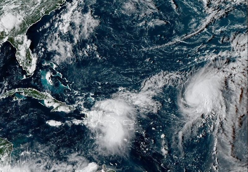
Editor's note: Follow the latest Atlantic hurricane season forecast updates for Friday, Sept. 26.
Meteorologists are warning of potential impacts to the Southeast U.S. coast from two offshore tropical disturbances, especially the tropical wave drenching portions of Puerto Rico and the Dominican Republic on Sept. 25.
"There's an increasing risk of impacts from this system across portions of the Bahamas and across portions of thesoutheast United States coastline as we go through the weekend and into early next week," Michael Brennan, National Hurricane Center Director, said in an afternoon update. That includes the possibilities of heavy rainfall, wind, and storm surge along portions from Florida into North Carolina, Brennan said.
He and other meteorologists warn that there remains a lot to sort out as the wave moves into the Bahamas, including its potential interactions with a weather system moving in from the west and the strengthening Tropical Storm Humberto to the east.
Though not well organized, the wave over the Caribbean is expected to produce a tropical depression by Friday, Sept. 26, or over the weekend, Brennan said.
At 5 p.m. on Sept. 25, the hurricane center put the wave's chances of storm formation at 80% over 48 hours. Brennan said rainfall will be "moving into the Turks and Caicos, and portions of the Bahamas as we go through the next couple of days."
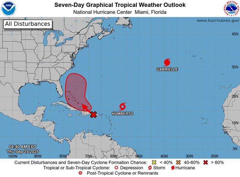
Humberto is gradually becoming better organized and forecast to reach hurricane status within 24 hours, the hurricane center said. It's forecast to experience steady to rapid strengthening and could become a major hurricane, with winds of 115 mph or more over the weekend. As of 5 p.m. ET Sept. 25, the center of Humberto was located about 470 miles northeast of the Northern Leeward Islands. It had maximum sustained winds of 60 mph and was moving to the northwest at 6 mph.
Confidence is also increasing in coastal impacts from a long-period swell from Humberto, the weather service said.
The hurricane center's official forecast calls for Humberto to move generally northward in the Atlantic, following a path similar to that of Hurricane Erin earlier in the season, and move just west of Bermuda on Sept. 30.
But that track isn't set in stone, and the forecasts for the storms are more uncertain than usual, as human forecasters and their computer models figure out how Humberto and the wave moving into the Bahamas could interact with each other and with a weather system moving across the United States.
Not only is the potential for impacts along the Southeast U.S. coast increasing, but the possibility of inland impacts also exists in eastern North Carolina, said Roger Martin, a meteorologist with the weather service in Morehead City, North Carolina. The extent of the impacts remains "heavily dependent" on its track and intensity, Martin said.
The eventual fates of the pair of tropical systems remain highly uncertain, according to forecasters.
"The interactions between these two systems will be highly complex and dependent on how each system behaves," Morgan Simms, a second meteorologist with the weather service in Morehead City said on the evening of Sept. 24. "Interactions like this in the Atlantic basin have little precedent – we don't have an appreciable historical record to draw reference to."
So far, the ensemble models used by forecasters to predict the path of hurricanes are pretty united on a path northward for Humberto, though a few outliers take it on a more westerly course.
By the afternoon of Sept. 25, many of the model ensembles were showing a path that could be a close call for the Southeast coast. The two systems might even interact through a process known as the Fujiwhara effect, forecasters said.
Roger Martin, a meteorologist with the National Weather Service office in Morehead City, North Carolina, reiterated the need for weather watchers to be careful with any of the hurricane model guidance they may encounter. "Because of the chaotic steering flow, a model run today may look vastly different than a run from the same model on a separate day," he said on Sep. 24.
Weather service offices are advising people to pay attention to the forecast into the weekend to be alert for any potential development.
Forecast uncertainty remains 'high'
Forecast uncertainty with the wave and Tropical Storm Humberto remains "high," the National Weather Service in Miami said on the morning of Sept. 25.
Several things make the forecast for the two storms offshore "tricky," wrote Andrew Hazelton, an associate scientist at the University of Miami's Cooperative Institute for Marine and Atmospheric Studies, in a summary on Sept. 24.
Among the factors making the forecast so uncertain are the potential action with each other in a potential Fujiwhara effect, and their interaction with a front moving into the Southeast, as well as the potential effects of the system closest to shore moving over the mountainous regions of Hispaniola.
So far, Hazelton said, the new Google DeepMind ensemble, which has been impressing forecasters with its accuracy, is split on whether the closest system could recurve out into the ocean or make landfall somewhere along the Southeast coast.
Hurricane forecasters watch US weather patterns
Weather patterns over the Lower 48 are also playing a role in the forecast for the tropical systems: In Miami, the weather service said a cut-off low-pressure system over the Southeast is expected to push a frontal boundary toward South Florida, then stall and dissipate north of Lake Okeechobee over the weekend and into early next week.
Meanwhile, there’s "a lot of uncertainty" with the tropical systems to the east, with high chances for development and how they might interact with each other and the frontal boundary.
Will there be tropical cyclone impacts in Florida?
Along Central Florida's east coast, the weather service in Melbourne said a high risk of life-threatening rip currents remains along the beaches as long-period swells from distant Hurricane Gabrielle continue to reach the coast, and advised small vessels to use caution.
Due to the tropical wave in the Northeast Caribbean, the weather service said it expects beach and boating conditions to deteriorate over the next seven days as the system moves toward the Bahamas. "It is too early to tell what if any other impacts East Central Florida could see," said meteorologist Robert Haley. "We recommend residents and visitors take this time to ensure their emergency plan is ready."
Hurricane hunter flights scheduled
At least a half-dozen hurricane hunter flights are scheduled for Sept. 25 and 26, so the hurricane center can keep an eye on the systems. Then, if a system develops from the wave moving into the Bahamas, additional flights would take place to get center position fixes every six hours, according to the reconnaissance schedule.
A rather quiet season … so far
So far this season, at eight named storms, 2025 is tied with 2024 for the fewest Atlantic named storms through Sept. 24 since 2014, said Phil Klotzbach, a senior research scientist at Colorado State University. He pointed out that the 2024 season concluded with 18 named storms.
What about Hurricane Gabrielle?
Hurricane Gabrielle is zipping across the Atlantic at 32 mph, about 535 miles west of the Azores. It's expected to cause hurricane conditions over the Azores by the morning of Sept. 26 and then begin transitioning to lose its tropical characteristics as it approaches the coast of Portugal over the weekend.
Storm tracker
This forecast track shows the most likely path of the center of the storm. It does not illustrate the full width of the storm or its impacts, and the center of the storm is likely to travel outside the cone up to 33% of the time.
Spaghetti models
Illustrations include an array of forecast tools and models, and not all are created equal. The hurricane center uses only the top four or five highest-performing models to help make its forecasts.
This article originally appeared on USA TODAY: Risks increasing for tropical impacts on Southeast US coast
Reporting by Doyle Rice, Dinah Voyles Pulver and Jeanine Santucci, USA TODAY / USA TODAY
USA TODAY Network via Reuters Connect

 News 19 WLTX
 Wilmington Star-News
 Star Beacon
 FOX 13 Tampa Bay Crime
 CNN
CNN The radio station 99.5 The Apple
 CBN Christian World News
 FOX Carolina
 AlterNet
 FOX News
 The List