
 USA TODAY National
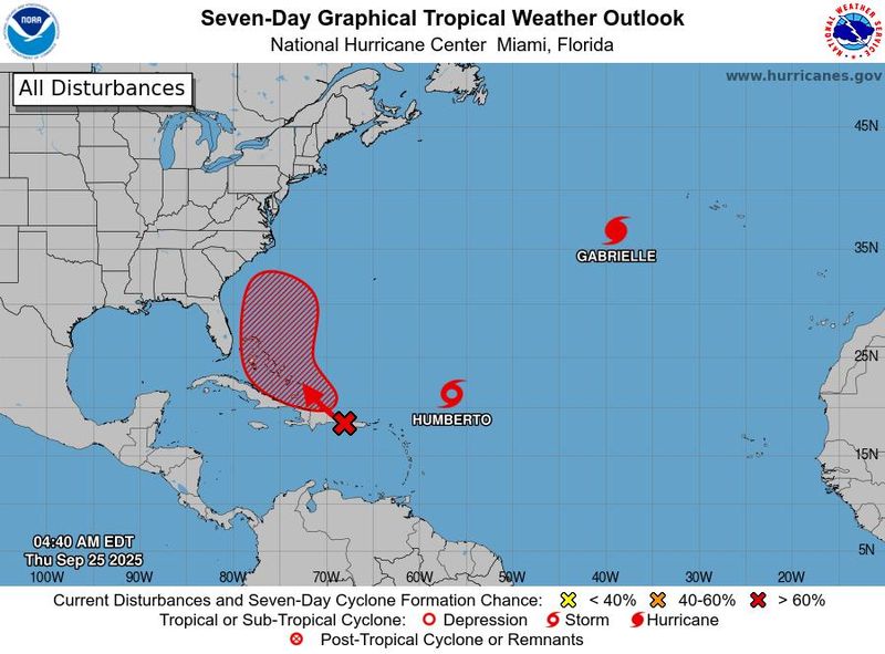
A disturbance in the Atlantic has formed, becoming Tropical Storm Humberto, the eighth named storm to form in the Atlantic.
According to an early morning advisory on Thursday, Sept. 25 by the National Hurricane Center, the storm is spinning in the central Atlantic and moving northwest at nearly 10 mph, with maximum sustained winds of 45 mph.
The storm is set to intensify significantly over the next two to three days as it moves over warm waters.
Tropical Storm Humberto is expected to reach hurricane strength over the weekend and become a significant hurricane during the week of Sept. 28, according to the NHC.
As of early Thursday morning, Tropical Storm Humberto was located in the central Atlantic, northeast of Puerto Rico and several hundred miles east-northeast of the northern Leeward Islands.
There are no coastal watches or warnings in effect related to the storm.
Tropical Storm Humberto tracker
This forecast track shows the most likely path of the center of the storm. It does not illustrate the full width of the storm or its impacts, and the center of the storm is likely to travel outside the cone up to 33% of the time.
Tropical Storm Humberto spaghetti models
Illustrations include an array of forecast tools and models, and not all are created equal. The hurricane center uses only the top four or five highest-performing models to help make its forecasts.
Where is Hurricane Gabrielle?
Meantime in the Atlantic, Hurricane Gabrielle is moving further away from the U.S. toward the Azores, an autonomous region of Portugal in the mid-Atlantic. It is expected to reach the islands late on Thursday, according to the NHC. The Meteorological Service of Portugal issued a hurricane warning for the islands.
The hurricane, now a Category 1, has maximum sustained winds near 85 mph, and is forecasted to be at hurricane strength when it reaches the islands.
The storm is expected to dissipate early Saturday morning, Sept. 27, before it reaches Portugal early Sunday morning, Sept. 28.
NHC tracking one more system in the Atlantic, Hurricane Narda in the Pacific
Humberto and Gabrielle are not the only tropical activities in the Atlantic Ocean, according to the NHC.
Forecasters said they are also keeping a close eye on Invest 94L, a tropical wave located in the Eastern Caribbean Sea near the Dominican Republic as of early Thursday morning.
The wave is producing disorganized showers and thunderstorms, and is expected to move most west-northwestward at around 10 to 15 mph, according to the NHC.
The storm will bring gusty winds and heavy rainfall to the Dominican Republic and Puerto Rico throughout the day.
The tropical wave is expected to turn northwestward once it reaches the southwestern Atlantic, and is expected to form into a tropical depression late this week once it is near the Bahamas.
If it forms, it would become Tropical Storm Imelda.
In the Pacific, Hurricane Narda, a Category 1 hurricane, spins in the eastern Pacific with maximum sustained winds of 90 mph.
The NHC has issued advisories as swells created by Narda affect areas of the southwestern and west-central Mexican coast. Later on Thursday, Sept. 25, the swells are expected to reach Baja California Sur, then southern California over the weekend.
"These swells are likely to cause life-threatening surf and rip current conditions," according to the NHC's public advisory.
How do hurricanes form?
Hurricanes are born in the tropics, above warm water. Clusters of thunderstorms can develop over the ocean when water temperatures exceed 80 degrees. If conditions are right, the clusters swirl into a storm known as a tropical wave or tropical depression.
A tropical depression becomes a named tropical storm once its sustained wind speeds reach 39 mph. When its winds reach 74 mph, the storm officially becomes a hurricane.
Prepare now for hurricanes
Delaying potentially lifesaving preparations could mean waiting until it’s too late. "Get your disaster supplies while the shelves are still stocked, and get that insurance checkup early, as flood insurance requires a 30-day waiting period," the National Oceanic and Atmospheric Administration recommends.
- Develop an evacuation plan. If you are at risk from hurricanes, you need an evacuation plan. Now is the time to begin planning where you would go and how you would get there.
- Assemble disaster supplies. Whether you’re evacuating or sheltering in place, you’re going to need supplies not just to get through the storm but for a possibly lengthy aftermath, NOAA said.
- Get an insurance checkup and document your possessions. Contact your insurance company or agent now and ask for an insurance checkup to make sure you have enough insurance to repair or even replace your home and belongings. Remember, home and renters insurance don’t cover flooding, so you’ll need a separate policy for those. Flood insurance is available through your company, agent or the National Flood Insurance Program.
- Create a family communication plan. NOAA says you should take the time now to write down a hurricane plan and share it with your family. Determine family meeting places and make sure to include an out-of-town location in case of evacuation.
- Strengthen your home. Now is the time to improve your home’s ability to withstand hurricanes. Trim trees and install storm shutters, accordion shutters, and impact glass, and seal outside wall openings.
Contributing: Gabe Hauari, USA TODAY
Julia is a Trending reporter for USA TODAY and covers all things Labubu and Pop Mart, scientific studies and trending news. Connect with her on LinkedIn, X, Instagram, and TikTok: @juliamariegz, or email her at jgomez@gannett.com
This article originally appeared on USA TODAY: Tropical Storm Humberto: See path tracker, spaghetti models
Reporting by Julia Gomez, USA TODAY / USA TODAY
USA TODAY Network via Reuters Connect

 WMAR-2 News
 WESH 2 News
 CBS4 Miami
 America News
 The Advocate
 Florida Today
 Sarasota Herald-Tribune
 KSNB Local4 Central Nebraska
 WAVE 3 News
 NBC12
NBC12 The Daily Beast