
 USA TODAY National
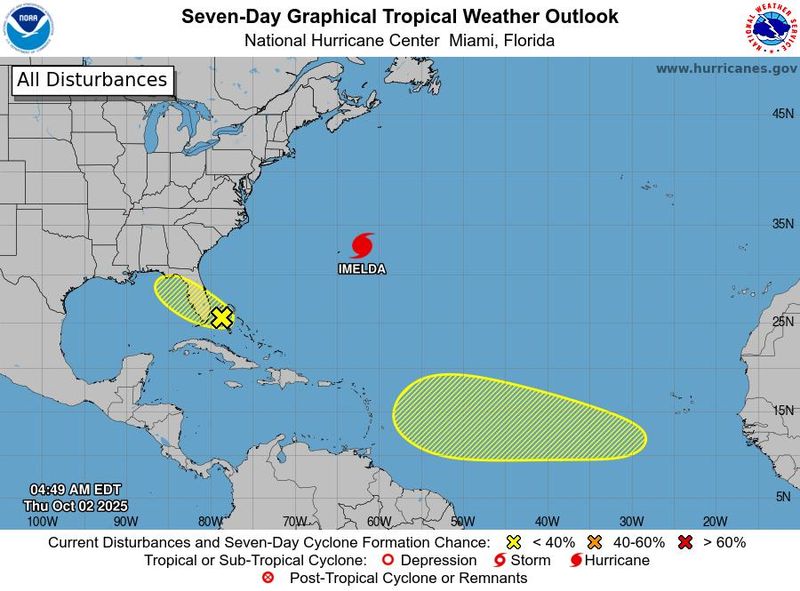

Four months down, two to go.
With four months gone by, the Atlantic hurricane season still has two full months to go, and forecasts indicate there are more storms to come.
Just a day after advisories ended on Hurricane Humberto, two new areas to watch for potential storm development had already popped up on a National Hurricane Center outlook map.
Overall, will the season wind up strong and match the forecasts that called for a busier-than-normal season? It still could, as storms can and do fire up in the final two months of the season.
In fact, just last year, seven storms formed in October and November, including four hurricanes, two of them major. There were also seven storms during that period during the hectic 2020 season, including four major hurricanes.
Forecasts for early October indicate that there's almost certainly more activity to come.
As if on cue, on the morning of Oct. 2, the two new potential storms appeared on the map.
One potential low pressure area could form near the northwestern Bahamas and southern Florida. Any development would be slow to occur as the system crosses Florida, the hurricane center reported, giving the system only a 10% chance of development over seven days. The second was given a 20% chance of development over the next week across a broad swath of the Atlantic from southwest of the Cape Verde Islands to just east of the Windward Islands on the east end of the Caribbean.
The 2025 hurricane season so far
"It's been an unusual season so far, with the really pronounced lull from late August through mid September, followed by a flurry of storm activity," said Colorado State University hurricane researcher Phil Klotzbach in an e-mail to USA TODAY.
"So far, the season is running a bit below normal for named storms and hurricanes but above-normal for major hurricanes," he said.
October Atlantic hurricane forecast
Colorado State University, in a two-week forecast released Oct. 1, calls for "slightly favor above-normal activity for the next two weeks," due in part to still-rampaging Hurricane Imelda. The hurricane pummeled Bermuda with hurricane-force winds overnight on Sept. 30 as it began transitioning to an extra-tropical storm, traveling at the speedy pace of 30 miles an hour.
The university's forecast cited "model signals for potential development in the central tropical Atlantic and in the northwest Caribbean/Gulf in week two."
In the Caribbean and Gulf, Klotzbach told USA TODAY that "there are indications of a robust potential for development around mid-October."
As well, the storm-boosting Madden-Julian Oscillation is now fairly weak, but there are some indications that it may start to intensify in the Indian Ocean during mid-October. "If that were to occur, it would favor Atlantic tropical cyclone activity," according to CSU.
Later in October, the National Oceanic and Atmospheric Administration's long-term outlook calls for a greater than 40% chance of tropical activity from an area in the western Caribbean Sea and southern Gulf of America, formerly known as Gulf of Mexico.
As for specific locations, Colorado State University favors "an above-average end to the Atlantic hurricane season in the Caribbean Sea."
How are the pre-season forecasts stacking up?
The pre-season forecasts from the National Oceanic and Atmospheric Administration, as well as Colorado State predicted a busier than normal season.
Even though it's been a quiet year for the U.S. mainland, the three major hurricanes so far match the minimum number of major hurricanes NOAA predicted. And it would only take one more hurricane to match its forecast for the minimum number of hurricanes, and it's still early yet.
On average, the ninth named storm and the fourth hurricane occur by Sept. 16. So 2025's ninth storm, Imelda, formed on Sept. 28, a little late in terms of the average season.
But in terms of major hurricanes, Humberto was far ahead of schedule. The third major hurricane arrives on average by October 28.
NOAA predicted 13 to 19 named storms, and Colorado State predicted 16 in its August adjusted forecast. With only nine named storms so far, it remains to be seen whether the season will come close to that prediction. In an average season, four named storms form in October and November.
While most people think of a season's activity in terms of the named storms, hurricane scientists also measure the accumulated cyclone energy that takes place with a total number of storm days in the ocean. By that measure, this season is already ahead of the energy that had been generated at this time last year, said Brian McNoldy, a senior research associate at the Rosenstiel School of Marine, Atmospheric, and Earth Science at the University of Miami.
But year-to-date, it's slightly below the long-term average, Klotzbach said.
Notable Fujiwhara effect, a rare phenomenon
For hurricane and weather scientists, this season will be memorable for the "Fujiwhara" activity between Imelda and Humberto the last week of September.
The Fujiwhara Effect is the interaction of two tropical systems that causes both to dance around each other like a spinning teacup amusement park ride or ballroom dancers moving in unison, AccuWeather said.
Hurricanes far out into the ocean give forecasters the opportunity to observe the powerful heat machines without worrying about catastrophic landfalls.
Just such an opportunity took place on Sept. 30, as they watched Imelda and Humberto approach each other. At one point, the centers of the two hurricanes were only 465 miles apart, McNoldy said.
No doubt they 'felt' each other and began to orbit counterclockwise around a common center before separating again," McNoldy told USA TODAY. But they did not conclude a full orbit around a common center or merge, he said, two types of interactions that can occur during a Fujiwhara effect.
The centers of the hurricanes were closer together than any other pair of storms in the Atlantic dating back to 1966, concluded Michael Lowry, a hurricane specialist at WPLG-TV in South Florida.
Water temperatures are warm
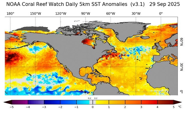
One key ingredient that could have an influence over any storms that form in the weeks ahead is sea surface temperatures. Warmer waters fuel hurricanes and water temperatures where hurricanes form in the Atlantic, Caribbean and the Gulf are warmer than normal, as shown on the map and chart below.
Doyle Rice and Dinah Voyles Pulver are national correspondents for USA TODAY, with decades of experience covering hurricanes, weather and climate. Reach them at drice@usatoday.com and dpulver@usatoday.com.
This article originally appeared on USA TODAY: Hurricane forecasters spot 2 new potential problems as a risky October begins
Reporting by Dinah Voyles Pulver, Doyle Rice, Jennifer Borresen and Ramon Padilla, USA TODAY / USA TODAY
USA TODAY Network via Reuters Connect

 NBC News
 The Grand Rapids Press
 WCNC Charlotte Weather
 WBKO
WBKO TIME
TIME WAFB
WAFB AccuWeather Severe Weather
 Raw Story
 AlterNet