
 USA TODAY National
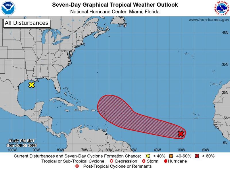
Forecasters are tracking a broad area of low pressure associated with a tropical wave in the Atlantic that has a medium to high chance of developing into a tropical cyclone, the National Hurricane Center said on Oct. 5.
The tropical wave, referred to as Invest 95L (AL95), has a 40% chance of formation over 48 hours and a 70% chance of formation over seven days, according to the National Hurricane Center in Miami. It is forecast to approach the Leeward Islands by late this week.
The broad area of low pressure is producing disorganized thunderstorms and showers several hundred miles south-southwest of the Cabo Verde Islands, the hurricane center said in a tropical outlook issued at 2 p.m. ET.
"Environmental conditions appear conducive for additional development of this system, and a tropical depression is likely to form this week as the system moves quickly across the central tropical Atlantic," the hurricane center said.
Forecasters are also tracking a weak area of low pressure located over the north-central Gulf, according to the hurricane center. The system is producing showers and thunderstorms near the coasts of Louisiana, Mississippi, and Alabama.
"This system is beginning to move inland over the Gulf coast and development is not expected due to strong upper-level winds and land interaction," the hurricane center said.
Track storms in the Atlantic
More than four months after the start of the 2025 Atlantic hurricane season, there have been several hurricanes and tropical storms churning in the tropics, but none have made landfall.
The Atlantic hurricane season runs from June 1 to Nov. 30 every year, with the most activity from August to October. Should another weather system develop into a tropical storm, the system would be named Jerry — which is next on the list of the 2025 Atlantic hurricane season names.
Tropical Storm Priscilla forms in Pacific Ocean near Mexico
Meanwhile, Tropical Storm Priscilla formed in the Pacific Ocean on Oct. 4, according to the hurricane center. By 1 p.m. ET on Oct. 5, forecasters said Priscilla was slowly strengthening and could bring heavy rainfall and gusty winds to coastal southwestern Mexico.
Priscilla's maximum sustained winds reached near 70 mph with higher gusts on Oct. 5, the hurricane center said. A tropical storm watch was in effect for areas between Punta San Telmo to Punta Mita, Mexico, and forecasters warned people in southern Baja California Sur to monitor the storm's progress.
"Additional strengthening is forecast during the next several days, and Priscilla is likely to become a hurricane later today or tonight," the hurricane center said in its 1 p.m. ET advisory.
Prepare now for hurricanes
Delaying potentially lifesaving preparations could mean waiting until it’s too late. "Get your disaster supplies while the shelves are still stocked, and get that insurance checkup early, as flood insurance requires a 30-day waiting period," the National Oceanic and Atmospheric Administration recommends.
- Develop an evacuation plan. If you are at risk from hurricanes, you need an evacuation plan. Now is the time to begin planning where you would go and how you would get there.
- Assemble disaster supplies. Whether you’re evacuating or sheltering in place, you’re going to need supplies not just to get through the storm but for a possibly lengthy aftermath, NOAA said.
- Get an insurance checkup and document your possessions. Contact your insurance company or agent now and ask for an insurance checkup to make sure you have enough insurance to repair or even replace your home and belongings. Remember, home and renters insurance don’t cover flooding, so you’ll need a separate policy for those. Flood insurance is available through your company, agent or the National Flood Insurance Program.
- Create a family communication plan. NOAA says you should take the time now to write down a hurricane plan and share it with your family. Determine family meeting places and make sure to include an out-of-town location in case of evacuation.
- Strengthen your home. Now is the time to improve your home’s ability to withstand hurricanes. Trim trees and install storm shutters, accordion shutters, and impact glass, and seal outside wall openings.
Contributing: Jennifer Sangalang, USA TODAY NETWORK - Florida
This article originally appeared on USA TODAY: Hurricane watchers eye tropical wave in Atlantic Ocean. See where it's heading
Reporting by James Powel and Thao Nguyen, USA TODAY / USA TODAY
USA TODAY Network via Reuters Connect

 Columbia Daily Tribune
 Lansing State Journal
 Truthout
 Newsday
 Billings Gazette
 The Columbian
 NBC News
 Associated Press Top News
 The Outer Banks Voice Community
 FOX Weather
 FOX News Videos