
 USA TODAY National
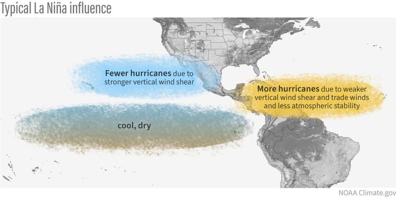
La Niña has officially arrived, federal forecasters from the Climate Prediction Center announced Thursday Oct. 9.
"La Niña conditions emerged in September 2025, as indicated by the expansion of below-average sea-surface temperatures across the central and eastern equatorial Pacific Ocean," the prediction center said in a statement.
As for how long it will last, "La Niña conditions are favored to persist through February 2026," according to the center.
Forecasters say this La Niña could impact the tail end of the 2025 hurricane season, and also have an effect on fall and winter weather in the United States.
What is La Niña?
La Niña is a part of a natural climate cycle officially known as El Niño-Southern Oscillation, called ENSO by scientists. The cycle swings between warmer and cooler seawater in a region along the equator in the tropical Pacific. La Niña is marked by cooler-than-average ocean water in the region.
It is one of the main drivers of weather in the United States, especially during the late fall, winter and early spring. It's the opposite of the more well-known El Niño, which occurs when Pacific Ocean water is at least 0.9 degrees warmer than average for three months.
The intermediate stage is known as ENSO-Neutral, when neither La Niña nor El Niño are present.
How could it impact hurricane season?
AccuWeather lead hurricane expert Alex DaSilva said in an online forecast that the emergence of La Niña "favors an active end to the hurricane season."
So far, as of Oct. 8, 10 named storms have formed in the Atlantic, of which four were hurricanes. An average season sees 14 storms and seven hurricanes.
Specifically, November tropical storms could be affected by La Niña, according to Matthew Rosencrans, lead hurricane seasonal forecaster with the National Oceanic and Atmospheric Administration.
"La Niña conditions are associated with more activity (double the amount) in November when compared to ENSO Neutral and especially when compared to Novembers with El Niño conditions," he said in an e-mail to USA TODAY.
When a La Niña phase occurs, less wind shear occurs in the regions of the Atlantic basin where tropical weather develops, increasing the potential for more storms, AccuWeather said.
Hurricane season officially ends Nov. 30.
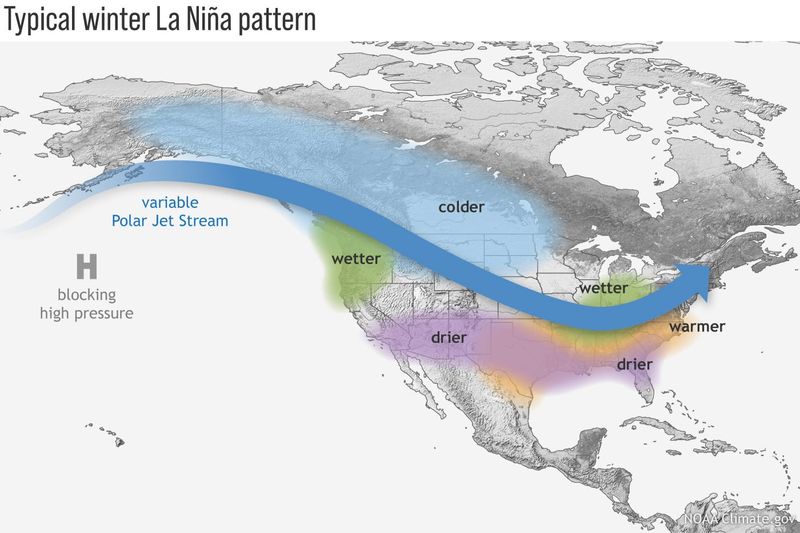
How will this La Niña impact our winter weather?
A typical La Niña winter in the United States brings cold and snow to the Northwest and unusually dry conditions to most of the southern states, according to the Climate Prediction Center. The Southeast and mid-Atlantic also tend to see higher-than-average temperatures during a La Niña winter.
In the East, the northern branch of the jet stream tends to carry faster-moving, less intense storms, which can mean snowfall near or even below average, with temperatures closer to seasonal norms, AccuWeather said.
Federal forecasters will release the government's official winter outlook on Oct. 16.
Why is the forecast important?
“Seasonal forecasts for El Niño and La Niña and their associated impacts on our weather are an important climate intelligence tool," said World Meteorological Organization secretary-general Celeste Saulo, in a recent statement.
"They translate into millions of dollars of economic savings for key sectors like agriculture, energy, health and transport and have saved thousands of lives when used to guide preparedness and response actions,” she added.
This article originally appeared on USA TODAY: La Niña has arrived, forecasters say. What does this mean for our weather?
Reporting by Doyle Rice, USA TODAY / USA TODAY
USA TODAY Network via Reuters Connect

 Fast Company
 NOLA
NOLA The Weather Channel
 KOMU 8
 The Spokesman-Review
 KPTV Fox 12 Oregon
 WCNC Charlotte Weather
 KCRA News
 WLWT
WLWT MassLive
 KPNX 12 News
 Raw Story
 5 On Your Side Sports