
 USA TODAY National
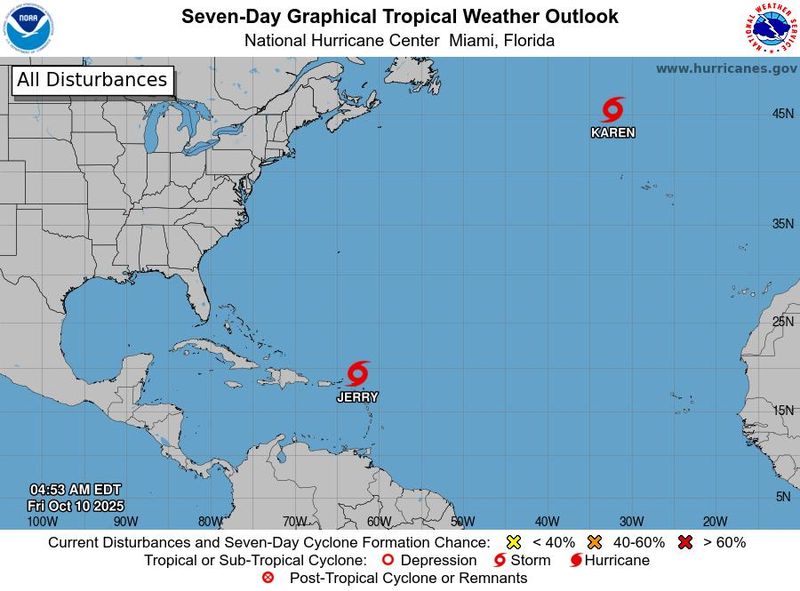
The 11th storm of the 2025 Atlantic hurricane season has gotten its name, with the formation of Subtropical Storm Karen way out at sea, as forecasters said on Oct. 10 that Tropical Storm Jerry has lost the steam to turn into a hurricane.
Karen formed late the night of Oct. 9 and by morning was located about 570 miles north-northwest of the Azores off of Portugal. As of Oct. 10, there were no threats to land predicted from Karen, which was moving 9 mph to the northeast with wind speeds of 40 mph.
The subtropical storm won't make it far before fizzling out into a post-tropical low by Oct. 11, the National Hurricane Center said. It will pick up a little in speed but not strength in the meantime, forecasters said.
Tropical Storm Jerry is meanwhile bringing heavy rain to the Caribbean island of Barbuda, along with the Leeward and Virgin islands, risking flash flooding, the hurricane center said. Puerto Rico could also see between 2 and 4 inches with localized amounts up to 6 inches.
Jerry was struggling to organize into a hurricane as forecasters previously predicted might happen toward the end of the week. Early on Oct. 10 it was passing to the north of the Leeward Islands and was located about 80 miles away, with wind speeds up to 50 mph.
As the final stretch of the 2025 Atlantic season is underway, no hurricanes have made landfall in the U.S., though four have formed so far. The Atlantic hurricane season officially began on June 1 and will last through the end of November. Experts say it's wise to stay prepared for potential impacts, as more hurricanes or strong storms could still form before then.
Tropical Storm Jerry not expected to become a hurricane
Jerry is no longer expected to become a hurricane, which would happen if it reached wind speeds of at least 74 mph. Jerry could still see some strengthening, but some forecast models suggest it won't strengthen further at all and there's some indication it will only weaken, forecasters said.
Despite not forming into a hurricane, Jerry is still bringing potentially dangerous rainfall and flash flooding risk to the Leeward and Virgin islands. Dangerous surf conditions are also extending out from the tropical storm.
Jerry is moving toward the northwest and is expected to make a northward turn later on Oct. 10, pulling away from the islands. Its center should move well to the southeast of Bermuda on Oct. 12. By early next week, Jerry is likely to turn more northeastward and eastward, forecasters said.
See the storms in the Atlantic
US faces dual storm threats this weekend
On the Atlantic Coast, a developing nor'easter on the horizon for the weekend is forecast to wreak havoc on a stretch from the Southeast to the Mid-Atlantic, likely reaching the Northeast. Coastal flooding and high surf, compounded by seasonal high tides, with dangerous rip currents and gusty winds are all possible from the storm, the National Weather Service said.
Tropical moisture from Hurricane Priscilla in the Pacific is meanwhile expected to bring heavy rainfall and potential flash flooding in the Southwest. Burn scars are particularly vulnerable to flooding in the region, forecasters said.
Read more.
Contributing: Doyle Rice and Dinah Voyles Pulver
This article originally appeared on USA TODAY: Subtropical Storm Karen forms in the Atlantic, becoming 11th named storm
Reporting by Jeanine Santucci, USA TODAY / USA TODAY
USA TODAY Network via Reuters Connect

 WESH 2 News
 ABC News US
 PIX11 News
 America News
 CBS Sacramento Dixon News
 Reuters US Top
 New York Post
 AlterNet
 @MSNBC Video
 CNN
CNN People Human Interest