
 WRCB-TV
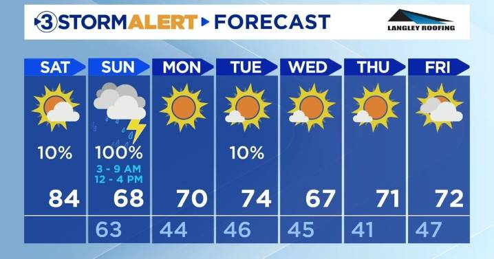
Happy Saturday, everyone!
Today will be partly cloudy with a high of 84. It will be the last toasty day for a while in the valley as temperatures are going to drop down to the upper-60s and lower-70s next week.
The morning and afternoon will be rain-free, but there is a slim chance for a rain shower or two between 5:00 to 6:00 PM EDT tonight. The low will be 63 with mostly cloudy skies.
Sunday beginning around 3:00 AM, strong to severe thunderstorms will be entering the Tennessee Valley along with a cold front. The first wave of storms will last until 9:00 AM, and there is a second wave between noon and 4:00 PM. The main risks include frequent lightning and damaging wind gusts between 30-50 mph. The system is expected to weaken as it approaches the valley. There is a 2% risk for tornado

 Hattiesburg American
 Ann Arbor News
 ABC News Weather
 AccuWeather Severe Weather
 FOX Weather
 NECN Providence
 Sweetwater Now
 KARE 11
 WIS News 10
 FOX 5 Atlanta Crime