
 USA TODAY National
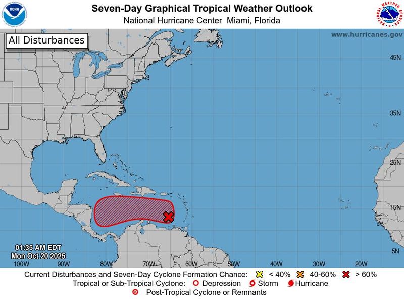
The National Hurricane Center is keeping an eye on a tropical wave in the eastern Caribbean Sea that could develop into a tropical depression later this week, however it is one that is not currently expected to impact the United States.
The storm, currently labeled as Invest 98L, is located a few hundred miles west of the Windward Islands and is producing "a large area of poorly organized showers and thunderstorms," the hurricane center said in an Oct. 20 advisory.
"Recent satellite-derived wind data indicate that the disturbance continues to lack a closed circulation, although it is producing winds of 30 to 40 mph to the north and east of the wave axis," hurricane center forecasters said in the advisory, noting that the system is moving quickly westward, which should "limit significant development during the next day or so."
Thereafter, environmental conditions are expected to become more conducive for development as the wave slows down over the central Caribbean Sea. Forecasters said that regardless of development, heavy rainfall and gusty winds are expected to continue affecting portions of the Windward and Leeward Islands Monday morning, Oct. 20.
The next named storm of the 2025 Atlantic hurricane season will be Melissa. The Atlantic hurricane season runs until Nov. 30.
Storm tracker
How do hurricanes form?
Hurricanes are born in the tropics, above warm water. Clusters of thunderstorms can develop over the ocean when water temperatures exceed 80 degrees. If conditions are right, the clusters swirl into a storm known as a tropical wave or tropical depression.
A tropical depression becomes a named tropical storm once its sustained wind speeds reach 39 mph. When its winds reach 74 mph, the storm officially becomes a hurricane.
Prepare now for hurricanes
Delaying potentially lifesaving preparations could mean waiting until it’s too late. "Get your disaster supplies while the shelves are still stocked, and get that insurance checkup early, as flood insurance requires a 30-day waiting period," the National Oceanic and Atmospheric Administration recommends.
- Develop an evacuation plan. If you are at risk from hurricanes, you need an evacuation plan. Now is the time to begin planning where you would go and how you would get there.
- Assemble disaster supplies. Whether you’re evacuating or sheltering in place, you’re going to need supplies not just to get through the storm but for a possibly lengthy aftermath, NOAA said.
- Get an insurance checkup and document your possessions. Contact your insurance company or agent now and make sure you have enough insurance to repair or even replace your home and belongings. Remember, home and renters insurance don’t cover flooding, so you’ll need a separate policy for those. Flood insurance is available through your company, agent, or the National Flood Insurance Program.
- Create a family communication plan. NOAA says you should take the time now to write down a hurricane plan and share it with your family. Determine family meeting places and make sure to include an out-of-town location in case of evacuation.
- Strengthen your home. Now is the time to improve your home’s ability to withstand hurricanes. Trim trees and install storm shutters, accordion shutters, and impact glass. Seal outside wall openings.
Gabe Hauari is a national trending news reporter at USA TODAY. You can follow him on X @GabeHauari or email him at Gdhauari@gannett.com.
This article originally appeared on USA TODAY: NHC tracking a tropical wave in the Caribbean Sea. Will it impact the US?
Reporting by Gabe Hauari, USA TODAY / USA TODAY
USA TODAY Network via Reuters Connect

 Times Herald-Record
 WESH 2 News
 America News
 FOX Weather
 The Daily Sentinel
 The Weather Channel
 FOX 10 Phoenix Latest
 Massillon Independent
 Raw Story