
 USA TODAY National
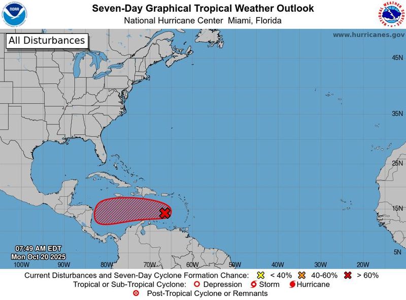
A weather system in the eastern Caribbean Sea continues to show signs of development on the afternoon of Monday Oct. 20, and forecasters say a tropical depression or tropical storm is likely to form within the next day or two. If it becomes a named storm as expected, it would get the name Melissa.
While the system could impact the islands of the Caribbean later this week or by the weekend, "none of our model guidance shows future Melissa posing any threat to Florida or the mainland U.S.," said WPLG-TV hurricane specialist Michael Lowry in a Substack post on Oct. 20.
"This is a concern for Caribbean interests – from Honduras and Nicaragua to parts of Cuba, Jamaica, Haiti, and the Dominican Republic – not us stateside in the U.S.," Lowry said.
If Melissa forms, it would be the 13th named storm of the 2025 Atlantic hurricane season. A typical year sees 14 storms, according to data from Colorado State University.
Where is the system now?
According to a bulletin from the National Hurricane Center released Monday Oct. 20, "a tropical wave located over the eastern Caribbean Sea is producing a concentrated area of showers and thunderstorms. The system is moving westward at 15 to 20 mph toward the central Caribbean Sea and is expected to slow down over the next few days."
"Compared to yesterday, surface observations suggest the circulation is gradually becoming better defined, and environmental conditions are forecast to become a little more conducive for development as the system slows its forward motion," the hurricane center said. The center added that environmental conditions are forecast to become more conducive for development, "and a tropical depression or storm is likely to form over the next day or two."
Maximum sustained winds would have to be at least 39 mph to be designated as a tropical storm.
Where will Melissa go?
Some of the computer models that meteorologist use to forecast storms show Melissa heading west toward Central America, while others show it slicing right towards Hispaniola or Cuba.
"At this time, the more likely outcome is the system eventually gets pulled northeastward by a dip in the jet stream toward Haiti and the Dominican Republic or eastern Cuba come late week into the weekend," Lowry noted.
Worryingly, "trends on several models indicate an impact to Haiti and the Dominican Republic is possible as soon as Thursday (Oct. 23), so folks there should be preparing for a possible hurricane impact," Andrew Hazelton, an associate scientist at the University of Miami's Cooperative Institute for Marine and Atmospheric Studies, said on X Oct. 20.
On the afternoon of Oct. 20, the hurricane center said,"interests in Puerto Rico, Hispaniola, Jamaica, and Cuba should monitor its progress as there is a risk of heavy rain and flooding, strong winds, and rough surface later this week."
Could future Melissa affect the mainland US?
Computer models indicate there will be no impact from Melissa to the mainland U.S.
Although late October and early November hurricane threats to the mainland U.S. can happen (and have happened), they’re the exception, not the rule, Lowry noted.
"The subtropical jet stream has sunk deep into the lower reaches of the Gulf and seems content on parking itself there for the foreseeable future," he said Oct. 20. "Strong upper-level winds associated with this subtropical jet will continue to act as a staunch barrier against would-be threats, tearing apart anything trying to get close to the U.S. coastline."
Spaghetti models for developing system
Special note about spaghetti models: Illustrations include an array of forecast tools and models, and not all are created equal. The hurricane center uses only the top four or five highest performing models to help make its forecasts.
This article originally appeared on USA TODAY: Tropical Storm Melissa is forming in the Caribbean. Where will it go?
Reporting by Doyle Rice, USA TODAY / USA TODAY
USA TODAY Network via Reuters Connect

 The Advocate
 WESH 2 News
 America News
 FOX 10 Phoenix Latest
 Florida Today
 FOX 32 Chicago
 WHAS 11
 WSIL-TV
 WNNY-TV
 WRCB-TV
 KSNB Local4 Central Nebraska
 The Daily Beast