
 ClickOrlando
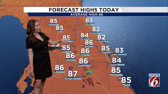
ORLANDO, Fla. – A shift in the weather pattern is on the way to Central Florida as cooler temps, stronger winds and rougher coastal conditions will settle in by the end of the week.
Wednesday
A weak cold front is moving through Wednesday. While most spots will stay dry, there’s a small chance (20%) of light showers, mainly offshore.
Ahead of the front, highs will be warmer than usual, in the mid- to upper 80s, before dropping into the 60s overnight.
[BELOW: Candace Campos tracks TS Melissa]
Thursday to Saturday
A stronger northeasterly wind pattern sets up behind the front. Winds will be breezy each day, between 15-20 mph, with gusts up to 30 mph along the coast. This will stir up rough surf and hazardous boating conditions. Beach erosion is something we’ll be watching closely, espe

 NewsNation
 FOX 13 Tampa Bay Crime
 People Top Story
 FOX 51 Gainesville Crime
 WFLA Florida
 Los Angeles Times
 Orlando Sentinel
 WCJB-TV20
 Florida Today
 Raw Story