
 KPAX
KPAX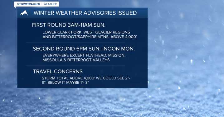
MISSOULA — Our next system is still on track to move in by Saturday morning with gusty winds possible throughout the day - especially in the mountains and across Southwest Montana, where gusts in the 25 mph to 40 mph range are likely.
Expect multiple, light to moderate waves of moisture through Monday with mainly mountain snow and valley rain — not a complete washout, but definitely unsettled.
Watch the forecast: Weather Forecast: 10.24.25
Snow levels will remain higher Saturday with an influx of warmer air (6,000’ - 7,000’) with most precipitation focused on the Montana/Idaho border and along the Divide.
With enough instability, a rumble or two of thunder isn’t out of the question. Valley highs Saturday will be in the low to mid 50s.
Erin Yost
Snow levels will drop overnight Satu

 KOMU 8
 KRIS 6 News Weather
 FOX 4 News Arlington
 Local News in Arizona
 Associated Press US and World News Video
 The Oregonian Public Safety
 Daily Voice
 FOX 13 Tampa Bay Crime
 WCBI-TV
 Associated Press Top News
 KPTV Fox 12 Oregon
 Raw Story
 IMDb Movies