
 USA TODAY National
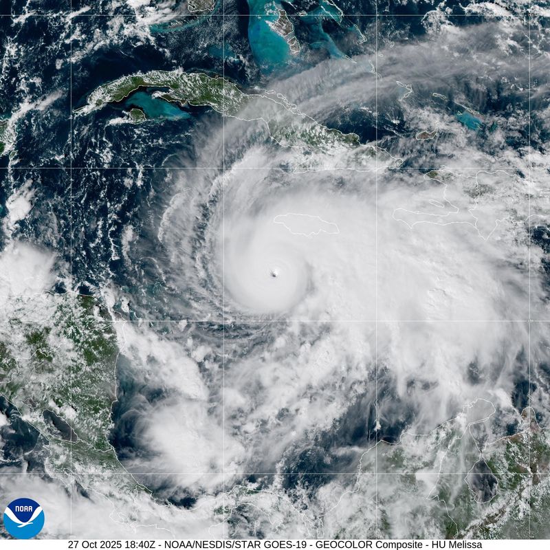
As Hurricane Melissa barreled toward Jamaica on Monday, Oct. 27, the nation braced for possibly its worst hurricane in recorded history, evacuating parts of its capital, closing airports and opening hundreds of shelters.
Melissa, a Category 5 storm, is expected to slam into the southern coast of Jamaica on Tuesday morning, Oct. 28, with catastrophic consequences. It's also set to approach Cuba as a major hurricane and cross the central and southeastern Bahamas, forecasters said. Melissa poses no direct threat to the United States.
The storm was centered about 140 miles southwest of Kingston, Jamaica, and 320 miles southwest of Guantanamo, Cuba, as of 5 p.m. ET on Oct. 27, the National Hurricane Center said. With maximum sustained winds of 175 mph with higher gusts, the storm has started its forecast turn to the north, moving at a sluggish 3 mph.
"It is possible" that the next reconnaissance flight might find Melissa's winds are even stronger than 175 mph, Jack Beven, a senior hurricane specialist at the hurricane center, wrote in a 5 p.m. forecast discussion.
By the afternoon of Monday, Oct. 27, the central barometric pressure in Melissa's center, one measure of the hurricane's power, had dropped to 906 millibars. That's the fourth lowest pressure for an October hurricane in the Atlantic basin since consistent pressures began being recorded in 1979, according to Colorado State University hurricane researcher Phil Klotzbach. It was also the lowest pressure for an Atlantic hurricane this late in the calendar year.
Fueled by the warm waters of the Caribbean, the storm underwent explosive growth over the weekend, its wind speed doubling from 70 mph to over 140 mph. Melissa is expected to intensify further as it approaches Jamaica, forecasters said.
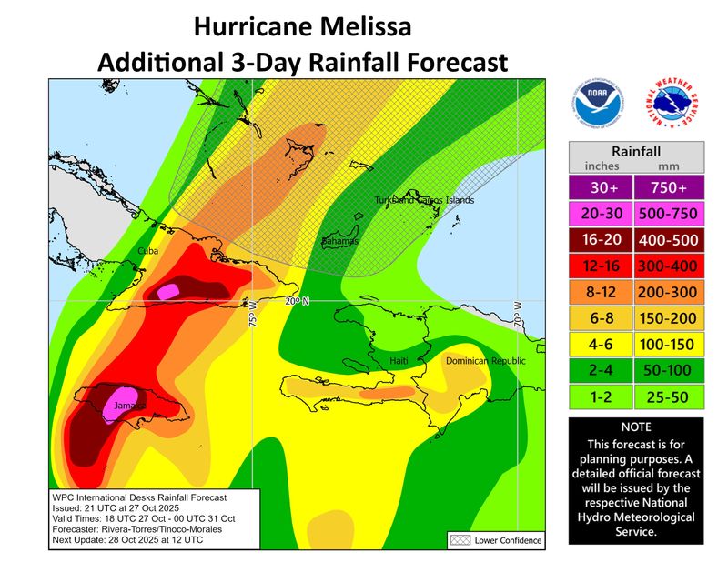
The storm's slow path forward increases the risks for record rainfall. The storm could drop 30 inches of rain over Jamaica – an amount Dana Morris Dixon, the country's information minister, said "we've never heard before."
In isolated locations, especially in mountainous regions of the island, rainfall could reach up to 40 inches, the hurricane center said.
On the coast, Melissa could push up a storm surge of up to 13 feet, topped by battering waves, forecasters said, warning of "catastrophic and life-threatening flash flooding."
"The time for preparation is all but over," Matthew Samuda, Jamaica's minister of water and environment, warned at a news conference.
Key messages from National Hurricane Center
In afternoon and evening updates on Oct. 27, Michael Brennan, hurricane center director, urged "everyone in Jamaica to be in a safe place where they're going to ride out the storm."
"Get to the sturdiest building that you can find," Brennan said. "There's a potential for total building failure near where the eyewall comes on shore and in areas of high terrain, as well as the potential for nine to thirteen feet storm surge inundation along the south coast near and where the center of Melissa makes landfall."
In Jamaica, the hurricane center warned that catastrophic winds in the eyewall have the potential "to cause total structural failure especially in higher elevation areas" on the night of Oct. 27 and Oct. 28. The storm could cause "extensive infrastructural damage, long-lasting power and communication outages, and isolated communities."
Brennan reminded people in the path of the hurricane to stay in shelters and not to venture outside as the hurricane's eye crosses over the islands.
A hurricane warning – meaning hurricane conditions are possible within 36 hours – is in effect for Jamaica, the Cuban provinces of Granma, Santiago de Cuba, Guantanamo and Holguin, and for the southeastern and central Bahamas. A hurricane watch – meaning hurricane conditions are possible within 48 hours – are in effect for the Turks and Caicos, and a tropical storm warning also is in effect for Haiti, the hurricane center said.
Torrential downpours already have affected Haiti and the Dominican Republic, and at least four deaths have been reported, according to Reuters. More than 3,650 residents in southern Haiti were moved into temporary shelters, and flights were suspended to and from the island's southern peninsula. Bahamian Prime Minister Philip Davis ordered evacuations for people in southern and eastern parts of the archipelago, and Cuban authorities said they had evacuated upwards of 500,000 people living in coastal and mountainous areas vulnerable to heavy winds and flooding, Reuters reported. More than 250,000 people were brought to shelters around Santiago de Cuba, the island's second-largest city, which lies squarely in the crosshairs of the hurricane's predicted path.
Cruise ships reroute to avoid Hurricane Melissa
Several cruise lines are changing plans to avoid Hurricane Melissa. Here are some examples:
Celebrity Beyond’s Oct. 26 itinerary will visit the Western Caribbean rather than the Eastern Caribbean, according to the cruise line’s parent company, Royal Caribbean Group.
Disney Treasure will stop in Cozumel, Mexico and spend two days at the line’s private Bahamas destination, Castaway Cay, rather than visiting Tortola and St. Thomas, the cruise line said.
Icon of the Seas’ Eastern Caribbean itinerary was replaced with a Western Caribbean cruise, visiting Cozumel in Mexico and Roatan, Honduras, according to Royal Caribbean Group.
– Nathan Diller
Where will Hurricane Melissa make landfall?
Experts anticipate Hurricane Melissa to make landfall along the western coast of Jamaica, near St. Elizabeth Parish, which has a population of over 150,000.
Evan Thompson, the director of the Meteorological Service of Jamaica, said the storm will is expected to move northeast across the country, exiting in the area of St. Ann Parish, where more than 170,000 people live. Both parishes are dotted with towns and cities of varying sizes.
The storm's track is well west of the nation's capital of Kingston, but the entire island could see 30 inches of rain and tropical force winds.
'This is not the end': Jamaican official briefs the public on Hurricane Melissa
Evan Thompson, the director of the Meteorological Service of Jamaica, said at a news conference that many parts of the country have begun to experience tropical force winds and heavy rainfall.
The impacts, he said, are expected to worsen through the day and overnight as the storm begins turning north, taking it on a path directly toward the island. He said while there's a "small window" where the storm could move further west and potentially miss the island, that's not the most likely scenario.
"Of course, all of us are hoping for that and praying for that, but at the same time we have to be practical," he said. "Right now, the projected path takes it to the southwestern part of Jamaica."
He finished his presentation by trying to calm residents: "Believe that we will get through it and we will get through it together. No one is alone. ... This is not the end."
Hurricane Melissa is still gaining strength
Melissa's wind speeds increased to 175 mph on the afternoon of Oct. 27, according to the National Hurricane Center.
"Some fluctuations in intensity are likely during the next 12-24 (hours) due to the possibility that Melissa will start an eyewall replacement cycle," the hurricane center said in an update.
"However, this is unlikely to weaken Melissa significantly, and there is no practical difference in Melissa making landfall in Jamaica at category 4 or 5 intensity, since both categories produce catastrophic wind damage," forecasters added. By 5 p.m., on Oct. 27, the center had not yet seen any evidence of the eyewall replacement starting.
A wild ride
Hurricane hunter flights into Melissa on Oct. 27 reported heavy turbulence. For Andrew Hazelton, an associate scientist at the University of Miami's Cooperative Institute for Marine and Atmospheric Studies, one of those flights was his first ride in a Category 5 hurricane and "the most turbulent" he'd ever experienced.
He was processing the data from the dropsondes ‒ equipment that collects data about the storm and transmits it to the center to assist with forecasting. That data was up there with "about as strong as Atlantic hurricanes can get," Hazelton posted on his X account.
A NOAA aircraft on the morning of Oct. 27 had to depart the hurricane earlier than expected after experiencing "severe turbulence in the southwestern eyewall," the hurricane center reported in a forecast discussion.
One of the hurricane hunter flights reported birds caught up by the storm and inside Melissa's eye.
Could Kingston, Jamaica, avoid the worst of Hurricane Melissa?
There may be a tiny shred of good news for Kingston, the capital of Jamaica: "As it stands right now, the center should cross the island about 60 miles west of Kingston, the population center of Jamaica," said Houston-based meteorologist Matt Lanza in a Substack post.
"Of course, that places Kingston on the stronger side of the storm but with hurricane force winds confined to about a 30-mile radius from the center, there’s likely going to be a buffer between the capital and the worst wind of the storm."
However, storm surge and heavy rainfall will still be a factor in Kingston.
Officials in recent days ordered evacuations in parts of Kingston vulnerable to flash-flooding and storm surge.
Guantánamo Bay orders evacuations as Hurricane Melissa nears
Beginning over the weekend, the Navy base at Guantánamo Bay began moving families off the island ahead of Hurricane Melissa's arrival.
"Non-mission-essential U.S. citizens will be moving off the island as early as Saturday afternoon and no later than Sunday morning," the Naval station told residents on Friday, Oct. 24. Evacuees were told to pack two weeks' worth of clothing and medication into one 40-pound bag.
Civilians were taken by shuttles to planes bound for Florida. Many families were taken to an air station in Pensacola.
According to the Department of War, previously known as the Department of Defense, the Navy base at Guantánamo Bay serves about 6,000 people, including joint services personnel, civilians, family members and others.
Melissa underwent 'rapid intensification'
Hurricane Melissa underwent what meteorologists call "rapid intensification," exploding from a 70-mph tropical storm Saturday morning Oct. 25 to a Category 4 hurricane with 140 mph winds by 5 a.m. Sunday, Oct. 26. It has since reached Category 5 strength, with winds of 175 mph.
Rapid intensification is a process in which a storm undergoes accelerated growth: The phenomenon is typically defined to be a tropical cyclone (whether a tropical storm or hurricane) intensifying by at least 35 mph in a 24-hour period.
The intensification was powered by unusually warm sea water in the Caribbean, which provides the energy for the storm to gather strength.
Jamaica prepares for landfall, floodwaters inundate Hispaniola
Jamaica and Hispaniola could see upwards of 30 inches of rain, forecasters said, warning of mudslides and "life-threatening flash flooding." Peak storm surge could reach 9 to 13 feet above ground level, and will be accompanied by destructive waves.
Through the midweek, eastern Cuba could see up to 20 inches of rain, as 9-foot waves crash along the coast.
The storm has already begun to wreak havoc. At least three deaths in Haiti have been linked to Melissa, according to The Associated Press. The storm has also inundated parts of the Dominican Republic, damaging over 100 homes and knocking out water service in several parts of the country, officials said.
In Jamaica, tourists evacuated as officials moved to close the nation's airports and open over 800 shelters ahead of the storm's arrival.
"Many of these communities will not survive this flooding,” said Desmond McKenzie, the minister of local government, at a news conference.
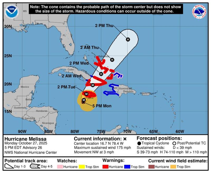
Where is Hurricane Melissa headed? See forecast tracker
This forecast track shows the most likely path of the center of the storm. It does not illustrate the full width of the storm or its impacts, and the center of the storm is likely to travel outside the cone up to 33% of the time.
Hurricane Melissa by the numbers
Melissa is the third Category 5 hurricane of the 2025 Atlantic season: Erin and Humberto were other two. Only one other Atlantic season on record has had more than two Category 5s: 2005, with Emily, Katrina, Rita and Wilma, Klotzbach said.
There has never been a Category 5 hurricane making landfall in Jamaica in the historical record, which dates back to 1851.
Five major hurricanes on record have made landfall in Jamaica, with Hurricane Gilbert (1988) the only Category 4 hurricane to make a direct landfall on the island, Klotzbach said on X. Gilbert made landfall with maximum winds of 130 mph.
Contributing: Eduardo Cuevas; Reuters
This article originally appeared on USA TODAY: Jamaica braces for 'catastrophic' impacts from 175-mph Hurricane Melissa: Updates
Reporting by Christopher Cann, Doyle Rice and Dinah Voyles Pulver, USA TODAY / USA TODAY
USA TODAY Network via Reuters Connect

 CBS4 Miami
 WFVX WVII News
 WFTV Channel 9
 Local News in New York
 Local News in Arizona
 Associated Press US and World News Video
 Reuters US Top
 Florida Today
 The Oregonian Public Safety
 Daily Voice
 RadarOnline
 Raw Story