
 WGCU Public Media
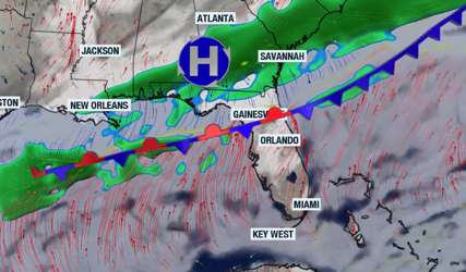
There will be drastic differences over the weekend between the northern and southern halves of Florida, with Central Florida mainly staying cloudy and with a high chance of showers due to the proximity of the cold and, eventually, a stationary front. This pattern will remain in place throughout the weekend, and another two fronts will push through the state next week, promising to finally kick out the unstable, stuck pattern we will have over the weekend and bring back the sunshine, lower the humidity, and cool the temperatures across the entire peninsula.
The forecast Northern Florida will continue to have rounds of showers on Friday. There's also a slight chance for a brief passing thunderstorm that could become strong. Friday's storm risk will be mainly focused over the western half of

 ClickOrlando
 Daily Voice
 WISC-TV Channel 3000
 WWSB
WWSB The Washington Post
 The Hill
 KSNB Local4 Central Nebraska
 WFMJ-TV
 WKOW 27
 WCNC Charlotte Weather
 The Oregonian Public Safety
 Essentiallysports Combat Sports