
 KFVS12
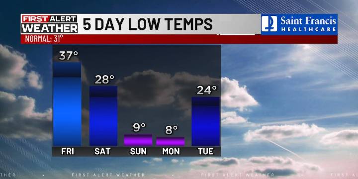
(KFVS) - Another cold front is on the way ahead of an even stronger front over the weekend.
This afternoon will be cloudy and chilly with highs in the low 40s before a cold front moves in this evening.
This front will create a small chance of snow showers in southern Illinois. No major impacts are expected.
Friday is looking partly cloudy with a breeze out of the northwest.
Afternoon highs will be in the mid-40s.
A strong cold front is on track to arrive Saturday, bringing a shot of arctic air over the weekend.
Highs on Saturday will struggle to reach the 30s and lows will drop into the teens and single digits.
It will be dangerously cold Saturday night and Sunday night, because wind chills will be near or below zero.
This bitter cold will stick around through the first part of nex

 ABC 6 WPVI-TV
 AccuWeather Severe Weather
 KETV NewsWatch 7
 KSL 5 TV
 KOMO News
 The List
 The Daily Beast
 NBC 7 San Diego Entertainmet
 AlterNet