
 WYMT
WYMT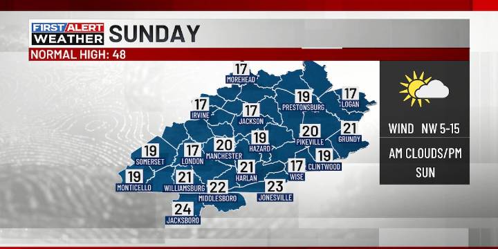
HAZARD, Ky. (WYMT) - More winter weather and bitterly cold temperatures are about to show up once again and last through the early part of next week.
Cloudy skies will be with us for this evening, with scattered snow showers arriving late in the evening and into the overnight hours. Up to an inch of new snow is expected, with up to 2 inches at higher elevations. Lower totals will be noted heading west towards the I-75 corridor. It turns frigid overnight with lows in the mid to upper teens and wind chills dipping to around zero.
Sunday will feature decreasing clouds throughout the day as it stays frigid. Highs will only be 15-20 degrees with wind chills in the upper single digits to low teens. Bitterly cold temperatures will be around Sunday night as we see lows 5 to 10 degrees above zero

 WSAZ NewsChannel 3
 WKOW 27
 WMTV NBC15
 The Motley Fool
 New York Magazine Intelligencer
 Salon
Salon America News
 Breitbart News
 Raw Story
 DoYouRemember?
 The Shaw Local News Sports