
 FOX 13 Tampa Bay Crime
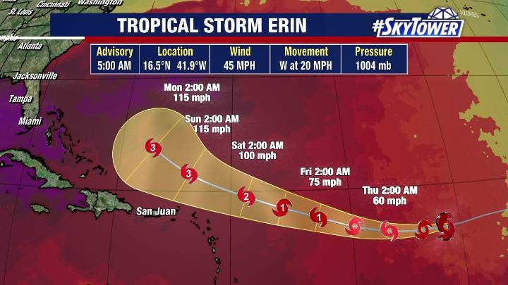
TAMPA, Fla. - Tropical Storm Erin hasn't gained much strength since forming on Monday over the Atlantic , but the National Hurricane Center says that should change soon as the storm moves west toward more favorable conditions for development.
Tropical Storm Erin's track
As of 5 a.m. Wednesday, Erin was located at 16.5N and 41.9W with maximum sustained winds of 45 mph.
The storm is moving west at 20 mph.
FOX 13 Meteorologist Dave Osterberg says Erin is getting some of its convection back, but it's also surrounded by Saharan dust, which has limited the storm's development so far.
Still, development should pick up in the next 48–72 hours as the storm moves over warmer water.
Erin should become the first Atlantic hurricane of the season late this week, according to Osterberg, then

 Ocala Star-Banner
 NBC 6 Florida
 Wilmington Star-News
 Florida Politics
 People Human Interest
 WWSB
WWSB AlterNet
 Idaho Statesman Entertainment
 Newsweek Top
 Raw Story
 America News
 Wheeling Intelligencer