
 WSIL-TV
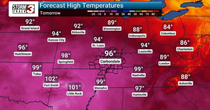
Southern Illinois and the surrounding region are under a prolonged stretch of heat and humidity to start the week. High temperatures through Tuesday will remain in the mid to upper 90s, with heat index values exceeding 100 degrees, making conditions dangerously hot. Residents should take precautions, especially during the peak afternoon hours.
Today features a slight chance of isolated thunderstorms, but most areas will remain dry. Any storm that forms could produce gusty winds and brief heavy rainfall. Beyond Tuesday, the hot and humid pattern begins to shift as a cold front moves through late Tuesday night into Wednesday.
The frontal passage will bring a welcome break from the oppressive heat, allowing temperatures to fall back toward seasonable levels in the mid to upper 80s. Daily st

 Eyewitness News 3
 Wilmington Star-News
 The Week
 WKOW 27
 FOX 10 Phoenix Latest
 FOX 32 Chicago
 WBRC
WBRC KSNB Local4 Central Nebraska
 KTVU San Francisco
 5 On Your Side Sports