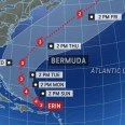
Erin evolved into a powerful Category 5 hurricane on Saturday morning with winds of 160 mph, and although it is now a Category 3, it is still posing a significant risk to lives and property. Heavy rain, strong winds and turbulent oceans are slamming parts of the Caribbean , including Puerto Rico, the British Virgin Islands and Hispaliola.
Erin will set its sights next on the East Coast of the United States, with the severity of impacts dependent on its track.
Erin is moving over water temperatures that are higher than the historical average not just at the surface but also hundreds of feet deep. These warm waters, combined with very little in the way of dry air and wind shear, have created "near perfect" conditions for rapid intensification, according to AccuWeather Lead Hurricane Ex

 AccuWeather Severe Weather

 Local News in South Carolina
 America News
 WISC-TV Channel 3000
 CNN
CNN Democrat and Chronicle
 FOX 13 Tampa Bay Crime
 New York Post
 Denver7 News
 NBC Bay Area Sports