
 FOX 59 News
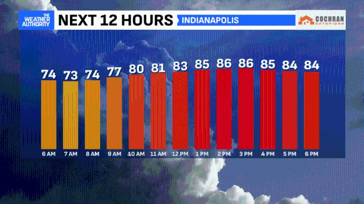
This morning will bring a few storms to dot the area, as temperatures hover in the 70s and higher dew points bring another muggy start to your day! Some lightning and a heavier downpour can't be ruled out in a few spots (especially north) for the rush hour but most areas will see little impact.
This afternoon will be another warm one with highs reaching the upper 80s, as additional storms move in along the cold front. A few of these storms could be on the stronger side with gusts, heavier rains and healthier lightning. We will monitor, as always!
Skies will clear in spots tonight and slightly cooler air will be noticed early Wednesday morning, as winds turn to the north. A drop in humidity will follow, marking a cooler day with a blend of clouds and sunshine. A weak shower chance remains

 WWSB
WWSB KETV NewsWatch 7
 America News
 Local News in South Carolina
 FOX 13 Tampa Bay Crime
 Florida Today
 FOX 51 Gainesville Crime
 Orlando Sentinel
 The Poughkeepsie Journal
 Hattiesburg American
 NBC12
NBC12 NBC News