
 News4JAX
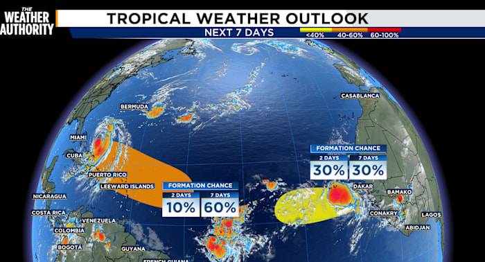
After Erin buzzes by our coast on Wednesday, another system may take its place soon.
Out in the heart of the tropical Atlantic, a tropical wave is stirring near the Leeward Islands. This system is the next in line to organize into a tropical storm, possibly, but that shouldn’t happen until the weekend. For now, it’s nothing more than a sprawling cluster of showers and thunderstorms—messy and unorganized—but the environment ahead looks increasingly favorable for gradual development.
If it does strengthen, the system is expected to trace a path similar to that of Hurricane Erin, moving west to west-northwest at about 20 mph. By Friday, it should be approaching the vicinity of the Leeward Islands. The odds of something spinning up remain low in the near termat just 10% over the next two day

 America News
 Local News in South Carolina
 FOX 13 Tampa Bay Crime
 Florida Today
 FOX 51 Gainesville Crime
 Orlando Sentinel
 The Poughkeepsie Journal
 NBC12
NBC12 Hattiesburg American
 Seeking Alpha Stock