
 WYFF Greenvile
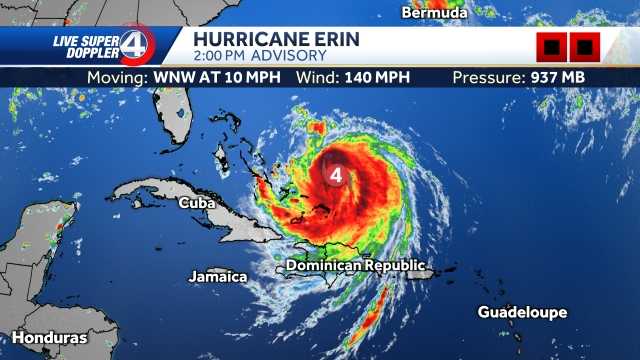
GREENVILLE, S.C. —
Hurricane Erin is now a Category 2, but the storm continues to grow in size.
While dry air and wind shear on its west side are keeping it from strengthening further right now, its expanding wind field means the storm’s impacts will spread wider.
Dangerous rip currents have already led to water rescues along parts of the coast, and conditions will only worsen heading into midweek.
Hurricane Stats:
Hurricane Stats
The track is now looking more locked in. As of Tuesday afternoon, Erin began its expected turn to the north, keeping the core “just offshore” of the East Coast rather than continuing its westward nudge. That’s good news, but the margin for error remains small — every mile matters.
Hurricane Track:
Hurricane Track
South Carolina Impacts
Rip Currents & Su

 WRAL News
 The Weather Channel
 FOX Carolina
 The Post and Courier
 WCBD News 2
 The Daily Beast
 Mediaite
 Raw Story
 Medscape
 Iron Mountain Daily Life