
 21Alive News
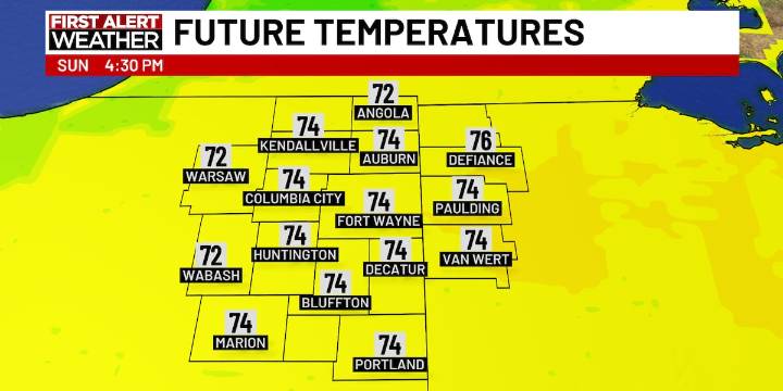
FORT WAYNE, Ind. (WPTA) - Cooler weather has arrived, and it will hang around for a decent portion of the next 7 days. The cold front that brought a few light showers on Saturday will pass through our area on Sunday morning. So, expect a crisp start to the day with morning temperatures in the upper 50s and low 60s. The afternoon temperature is expected to only top out in the mid 70s. Fortunately, they day will be dry and we’ll see a good amount of sunshine and blue sky.
Monday will be even chillier. Temperatures in the afternoon are only expected to top out near 70 degrees, with a few locations only getting to the upper 60s. This will be the same situation on Tuesday afternoon. Both Monday and Tuesday, a lake-effect rain shower (yes, rain shower, not snow shower) is possible, but the chan

 The Washington Post
 Essentiallysports Football
 WITN-TV
 KSNB Local4 Central Nebraska
 KOMU 8
 ABC News Weather
 WKOW 27
 Associated Press US News
 FOX Weather
 The Babylon Bee
 ESPN NFL Headlines