
 KKTV 11 News
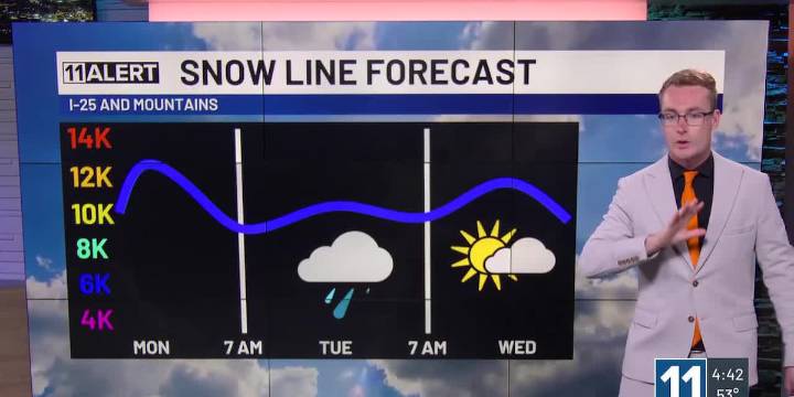
Warm Monday with afternoon and evening storms.
Cold front cools us down this evening, strong winds!
More showers and storms Tuesday, could we see snow?
MONDAY: Storm chances increase this afternoon. Some could be strong, maybe even severe out east with hail, wind and even a tornado possible. Highs reach the upper 70s and 80s. A cold front arrives later this afternoon and evening, quickly dropping our temperatures, producing a second line of storms after dark, and kicking up the winds! Gusts could be up to 40-50 mph.
TUESDAY: Showers and a few storms continue overnight and in the morning. Temperatures could decline just enough to drop the snow line to 9,000′ or 10,000′, so places like Woodland Park could see a few snowflakes flying! Better storm chances return in the afternoon, when t

 Associated Press US and World News Video
 CBS DFW
 KSNB Local4 Central Nebraska
 Democrat and Chronicle
 Hawaii News Now
 The Oregonian Public Safety
 CW39 Houston
 FOX 10 Phoenix Latest
 KTVU San Francisco
 KRQE News 13
 AlterNet