
After a round of strong to severe storms and widespread, soaking rain Monday night, Tuesday will end up a little calmer. Morning showers and storms will give way to a mostly cloudy afternoon with highs around 80°. The break won't last long with more active weather firing up overnight into Wednesday. Watch for additional strong to severe storms Wednesday afternoon/evening with damaging wind the primary threat. A cold front will track through Thursday morning with lingering showers and isolated t-storms and cooler highs in the 70s. Expect another 2" to 4" of rain over the next 3 days and watch for localized flooding. We'll clear out Friday and have a spectacular first fall weekend to enjoy.
A Few Lingering Showers and Storms Tuesday
 LEX 18 News13 hrs ago
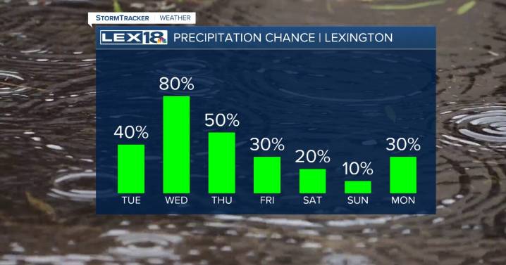
16

 WAAY TV
 News Channel 36
 Dakota News Now
 KRON4 News Bay Area
 FOX 5 Atlanta Crime
 FOX Weather
 The Mercury News
 KSLA News
 FOX 4 News Arlington
 KSNB Local4 Central Nebraska
 Eyewitness News 3
 5 On Your Side Sports