
 USA TODAY National
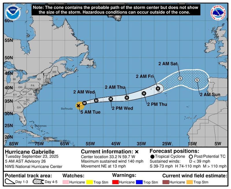
Hurricane Gabrielle has picked up strength as it continues to move northeastward into open water, according to the National Hurricane Center.
Forecasters said in an early morning advisory on Tuesday, Sept. 23 that Gabrielle was located about 305 miles east-northeast of Bermuda with maximum sustained winds near 140 mph with higher gusts, making it a Category 4 hurricane on the Saffir-Simpson Hurricane Wind Scale.
The hurricane center some gradual weakening is expected during the next couple of days as the storm continues to move in a general northeastward direction. On the forecast track, the center of Gabrielle is expected to move away from Bermuda Tuesday, according to forecasters.
While the storm is moving away from the eastern U.S. coast, swells generated by Gabrielle are expected to continue affecting the coast from North Carolina northward, in addition to Atlantic Canada, over the next few days. These swells are expected to produce life-threatening surf and rip current conditions, the hurricane center said.
Hurricane Gabrielle tracker
This forecast track shows the most likely path of the center of the storm. It does not illustrate the full width of the storm or its impacts, and the center of the storm is likely to travel outside the cone up to 33% of the time.
Hurricane Gabrielle spaghetti models
Illustrations include an array of forecast tools and models, and not all are created equal. The hurricane center uses only the top four or five highest-performing models to help make its forecasts.
NHC tracking 2 other systems in Atlantic that could cause trouble for US
In addition to Gabrielle, the hurricane center said it is also tracking two tropical waves in the Atlantic that could be cause for concern for the southeastern United States.
The first wave is located about 1,000 miles east of the Lesser Antilles and is causing shower and thunderstorm activity, according to forecasters. Environmental conditions are expected to become more favorable for development on Sept. 23, with a tropical depression likely forming later this week.
Hurricane center forecasters give the system an 80% chance of formation through the next seven days as it moves west-northwestward across the western Atlantic.
The second wave is currently located about 100 miles east of the Leeward Islands and is producing "concentrated, but disorganized, showers and thunderstorms," according to the hurricane center. Forecasters said environmental conditions appear marginally conducive for some development over the next few days.
"By the latter part of this week, the system is expected to slow down and turn northwestward, and a tropical depression could form late this week when the system is over the southwestern Atlantic Ocean or near the Bahamas," the hurricane center said in a Sept. 23 advisory.
The wave is forecast to bring gusty winds and heavy rainfall to portions of the Leeward Islands on Tuesday, Sept. 23, and Puerto Rico and the Virgin Islands late Tuesday into Wednesday, Sept. 24.
Tropical Storm Narda spins in the Pacific
Meanwhile in the Pacific, Tropical Storm Narda is nearing hurricane strength as it continues to spin well offshore the southwestern coast of Mexico, according to the hurricane center.
In a Sept. 23 advisory, forecasters said Narda was located about 255 miles south-southwest of Manzanillo, Mexico with maximum sustained winds near 70 mph with higher gusts. Narda is expected to strengthen into a hurricane on Tuesday, with little change in strength forecast Wednesday and Thursday.
Narda is moving west at about 13 mph, according to the hurricane center, and this general motion is expected to continue during the next several days. There are currently no hazards affecting land stemming from Narda.
Gabe Hauari is a national trending news reporter at USA TODAY. You can follow him on X @GabeHauari or email him at Gdhauari@gannett.com.
This article originally appeared on USA TODAY: Where is Hurricane Gabrielle headed? See path tracker for Category 4 storm
Reporting by Gabe Hauari, USA TODAY / USA TODAY
USA TODAY Network via Reuters Connect

 CBS4 Miami
 CBS Philly
 10 Tampa Bay
 Dakota News Now
 KRON4 News Bay Area
 FOX 5 Atlanta Crime
 FOX Weather
 WOWT Crime
 The Mercury News
 KSLA News
 WFMJ-TV Entertainment
 FOX 4 News Arlington