
 USA TODAY National
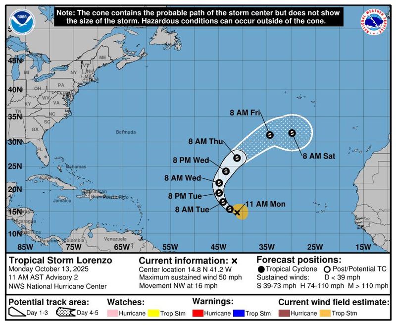
Tropical Storm Lorenzo, the 12th named storm of the 2025 Atlantic hurricane season, formed on Monday morning, Oct. 13, but it is not expected to have any impact on the United States.
The National Hurricane Center said in an Oct. 13 advisory Lorenzo was located about 1,150 miles west of the Cabo Verde Islands with maximum sustained winds near 50 mph with higher gusts. Forecasters said little change in strength is expected through early Tuesday, Oct. 14, but some "gradual intensification" is possible by the middle portion of the week.
Lorenzo is moving toward the northwest around 16 mph and this motion, with a gradual slowdown, is expected through Monday night, followed by a turn to the north on Tuesday, Oct. 14, according to the advisory. The storm poses no threat to any land areas, and "there are no coastal watches or warnings in effect," the hurricane center said.
The 2025 hurricane season continues to rack up named storms, though few are directly impacting any land areas. A typical season, based on data from 1991 to 2020, has 14 named storms, according to Colorado State University forecasters.
The Atlantic hurricane season runs until Nov. 30.
Tropical Storm Lorenzo tracker
This forecast track shows the most likely path of the center of the storm. It does not illustrate the full width of the storm or its impacts, and the center of the storm is likely to travel outside the cone up to 33% of the time.
Tropical Storm Lorenzo spaghetti models
Illustrations include an array of forecast tools and models, and not all are created equal. The hurricane center uses only the top four or five highest-performing models to help make its forecasts.
How do hurricanes form?
Hurricanes are born in the tropics, above warm water. Clusters of thunderstorms can develop over the ocean when water temperatures exceed 80 degrees. If conditions are right, the clusters swirl into a storm known as a tropical wave or tropical depression.
A tropical depression becomes a named tropical storm once its sustained wind speeds reach 39 mph. When its winds reach 74 mph, the storm officially becomes a hurricane.
Prepare now for hurricanes
Delaying potentially lifesaving preparations could mean waiting until it’s too late. "Get your disaster supplies while the shelves are still stocked, and get that insurance checkup early, as flood insurance requires a 30-day waiting period," the National Oceanic and Atmospheric Administration recommends.
- Develop an evacuation plan. If you are at risk from hurricanes, you need an evacuation plan. Now is the time to begin planning where you would go and how you would get there.
- Assemble disaster supplies. Whether you’re evacuating or sheltering in place, you’re going to need supplies not just to get through the storm but for a possibly lengthy aftermath, NOAA said.
- Get an insurance checkup and document your possessions. Contact your insurance company or agent now and make sure you have enough insurance to repair or even replace your home and belongings. Remember, home and renters insurance don’t cover flooding, so you’ll need a separate policy for those. Flood insurance is available through your company, agent, or the National Flood Insurance Program.
- Create a family communication plan. NOAA says you should take the time now to write down a hurricane plan and share it with your family. Determine family meeting places and make sure to include an out-of-town location in case of evacuation.
- Strengthen your home. Now is the time to improve your home’s ability to withstand hurricanes. Trim trees and install storm shutters, accordion shutters, and impact glass. Seal outside wall openings.
Contributing: Doyle Rice, USA TODAY
Gabe Hauari is a national trending news reporter at USA TODAY. You can follow him on X @GabeHauari or email him at Gdhauari@gannett.com.
This article originally appeared on USA TODAY: See Tropical Storm Lorenzo path tracker, spaghetti models
Reporting by Gabe Hauari, USA TODAY / USA TODAY
USA TODAY Network via Reuters Connect

 News4JAX
 Florida Today
 13WMAZ
 FOX 26 Harris County
 Click2Houston
 CW39 Houston Crime
 WWL-TV
 FOX 11 Orange County
 WFAA
WFAA Concho Valley
 Mediaite