
 USA TODAY National
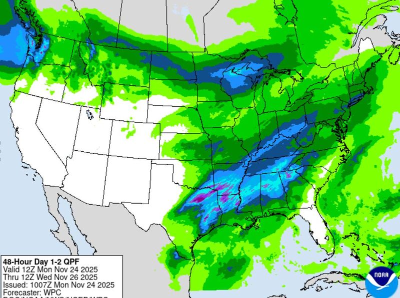
Storms across much of the central United States prompted a flurry of storm advisories on Monday, Nov. 24, with forecasters warnings of flooding in the South and heavy snowfall in the Great Lakes and upper Plains regions.
A low-pressure system developing over the southern US, which is being fueled by moisture from the Gulf, could bring flooding rains to eastern Texas, northern Louisiana, southern Arkansas and western Mississippi early this week, according to the National Weather Service.
Some of the heaviest rainfall is expected in the Texas Hill Country, where more than 130 people were killed in July when torrential rainfall turned rivers into rushing torrents of water. While the forecast isn't as dire as the historic summer storm, forecasters warned of possible river flooding.
The state has already begun seeing travel delays. Departures at Dallas Fort Worth International Airport, which is among the busiest airports in the country, were temporarily grounded, according to the Federal Aviation Administration. More than 80 flights at the airport were canceled and over 140 were delayed, according to FlightAware, a flight tracking website.
The latest storm comes days after heavy rain late last week turned streets in central Texas into rivers. RVs and some campsites in the Texas Hill Country were evacuated, and authorities in the Dallas area enacted road closures.
Over the coming days, the storm is expected to move north, bringing downpours to the lower Great Lakes, Ohio Valley, Mid-Atlantic region and parts of New England through Wednesday, Nov. 26.
Where are flood watches active? See map
Winter weather advisories active across north-central US
The northern Plains and Great Lakes regions are expected to receive multiple inches of snow over the coming days, especially in areas of high elevation.
The anticipated snow is associated with a frontal system moving inland across the Pacific Northwest. A stretch along the Canadian border, including Montana, North Dakota and Wisconsin could see a half foot of snow, according to the weather service.
Forecasters warned of heavy winds up to 55 mph in some parts of the region.
"Plan on slick road conditions," said the weather service office in Billings, Montana. "Areas of blowing snow could significantly reduce visibility. The hazardous conditions will impact the Monday evening and Tuesday morning commutes. Secure any loose objects."
(This story was updated to add new information.)
This article originally appeared on USA TODAY: Flood watches, winter storm advisories active across US
Reporting by Christopher Cann, USA TODAY / USA TODAY
USA TODAY Network via Reuters Connect

 CBS DFW
 Associated Press US News
 The Weather Channel
 The Gleaner
 CNN Video
 Reuters US Domestic
 Raw Story
 CNN
CNN America News
 AlterNet