
Madison Download the 27 StormTrack Weather app to receive mobile weather alerts For your Saturday night, a low-pressure system to our south is causing snow throughout southern and central Wisconsin. Models are starting to converge, with the most likely range for Madison being 1-3". Totals will be higher as you move southwest. This will last until 6 AM tomorrow. As for temperatures tonight, we will see lows in the mid-teens. After the snow ends tomorrow morning, we will see mostly sunny skies and cold temperatures with highs only reaching the upper teens. Wind chills will be in the single digits and could even get into the negatives. Eau Claire Download the 27 StormTrack Weather app to receive mobile weather alerts A low-pressure system south of Wisconsin will bring s
Continued Snow in Southern Wisconsin and Cold Temps on the Way
 WKOW 2712/07
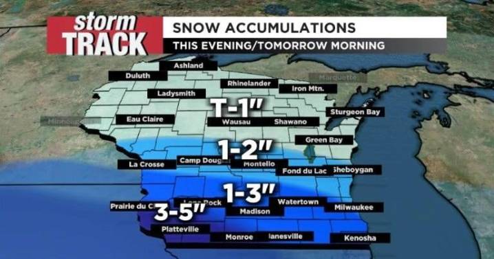
59

 WISC-TV Channel 3000
 Local News in Illinois
 1011 Now Lincoln
 America News
 WCBI-TV
 The Seattle Times
 Hawaii News Now
 WKYT
WKYT WWSB
WWSB NBC12
NBC12 The Daily Bonnet