
 WAFB
WAFB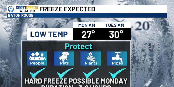
BATON ROUGE, La. (WAFB) - We’ll reach the 70s today and Saturday, then a strong cold front will move through, with plummeting temperatures into early next week.
TGIF FORECAST
Friday will be partly sunny and warmer with highs in the lower 70s in the afternoon. There will be a slight chance of showers, both AM and PM, with the better chance from mid-morning through early afternoon. Any precipitation is expected to be light.
GEMINIDS METEOR SHOWER
One of the best meteor showers of the year will be peaking this weekend, but the weather won’t cooperate Saturday night as a cold front comes through. There will be chances to see the shower Friday night and Sunday night too. Happy hunting!
STRONG COLD FRONT COMING
We’re tracking a strong cold front for this Saturday night into early Sunday AM

 KNOE
KNOE WPRI 12
 KXLY 4 News
 KSLA News
 NOLA
NOLA WDSU New Orleans
 BRProud
 Raw Story