
 WMAR-2 News
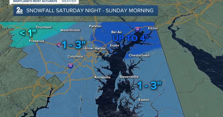
BALTIMORE — Happy Saturday! Light accumulating snow to the area starting tonight and will linger into Sunday morning. As of right now, anywhere a general 1-3" of snow is expected for the majority of the area, especially along I-95. Isolated spots across northeast MD could see up to 4". If you're traveling either Saturday night or Sunday morning, drive carefully as some untreated roads could be slippery. Turning bitterly cold on Monday morning, thanks to blustery winds. Trending milder through the middle of next week!
Stay weather aware!
Increasing clouds, with a high near 44. West wind 5 to 7 mph.
Rain and snow, becoming all snow. The snow could be heavy at times. Low around 26. Calm wind becoming northwest 5 to 7 mph after midnight.
A chance of snow. Partly sunny, with a high near 32.

 WCBI-TV
 CBS Philly
 WUSA 9 News
 Arizona's Family
 KIMT News 3
 WFMJ-TV
 Delaware County Daily Times
 WCNC Charlotte Weather
 Times West Virginian
 The Daily Beast