
 ABC11 WTVD
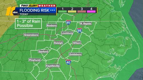
RALEIGH, N.C. (WTVD) -- Not only are we experiencing the coolest August on record, but central North Carolina is also seeing one of the rainiest starts to the month.
The unsettled wet weather pattern will continue into Thursday as thunderstorms could soak the area each day .
The area could see 1-3 inches of rain with the heavier downpours and slow-moving storms. Given the already saturated surfaces, these totals could produce quick rises on area creeks and localized flooding. Ponding of water on roads is also likely.
There was a flash flood warning for Moore County until noon and one for Wake County until 2 p.m.
ALSO SEE | Tropical Storm Erin forms in Eastern Tropical Atlantic
Businesses clean flood damage
Days after torrential rain caused flooding along Capital Boulevard

 People Crime
 WCCB Charlotte Crime
 Statesville Record & Landmark
  WITN-TV
 The Outer Banks Voice Community
 WRAL News
 WFMY News 2 Crime
 WBTV Mecklenburg County
 Queen City News North Carolina
 Glam
Glam